IMAGES TAKEN NEAR TO
Ansari Court, PONTYCLUN, CF72 8TD
Introduction
This page details the photographs taken nearby to Ansari Court, CF72 8TD by members of the Geograph project.
The Geograph project started in 2005 with the aim of publishing, organising and preserving representative images for every square kilometre of Great Britain, Ireland and the Isle of Man.

There are currently over 7.5m images from over14,400 individuals and you can help contribute to the project by visiting https://www.geograph.org.uk
Image Map
Images are licensed for reuse under creativecommons.org/licenses/by-sa/2.0
Notes
- Clicking on the map will re-center to the selected point.
- The higher the marker number, the further away the image location is from the centre of the postcode.
Image Listing (19 Images Found)
Images are licensed for reuse under creativecommons.org/licenses/by-sa/2.0
Image
Details
Distance
1
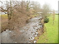
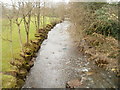
River Ely upstream, Ynysmaerdy
The view upstream from a footbridge http://www.geograph.org.uk/photo/2263788 connecting the car park with the hospital buildings at the Royal Glamorgan Hospital. http://www.geograph.org.uk/photo/2263805
Image: © Jaggery
Taken: 9 Feb 2011
0.06 miles
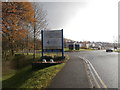
3
Ely Valley Road between Ynysmaerdy and Talbot Green
Ely Valley Road (A4119) heads SE towards Talbot Green. The sign shows Cardiff 14, Bridgend 14 (distances in miles).
Image: © Jaggery
Taken: 9 Feb 2011
0.10 miles
4
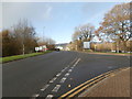
Looking towards the Ynysmaerdy roundabout from the Royal Glamorgan Hospital
A rainbow appears to have one end on the roundabout.
Image: © John Lord
Taken: 25 Nov 2017
0.10 miles
5

Footbridge at Royal Glamorgan Hospital
Leading from near the main entrance into the car parks.
Image: © Steve Barnes
Taken: 19 Jul 2024
0.11 miles
6
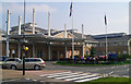
Royal Glamorgan Hospital
Main entrance of the Royal Glamorgan Hospital. This district general hospital was opened in 2000 and replaced the former East Glamorgan Hospital at Church Village.
Image: © Chris Hodcroft
Taken: 14 Apr 2007
0.12 miles
7
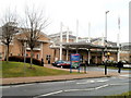
Main entrance to Royal Glamorgan Hospital, Ynysmaerdy
The hospital, located to the NW of Llantrisant, was built during the 1990s and officially opened in 2000. Unlike many older hospitals in cramped urban locations, this hospital benefits from being built on a large greenfield site. There are spacious car parks on the west side of the site, separated from the hospital buildings by the River Ely. Two footbridges http://www.geograph.org.uk/photo/2263788 give access across the river. The site also benefits from regular bus services which stop a few metres from the main entrance.
Image: © Jaggery
Taken: 9 Feb 2011
0.12 miles
8
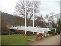
Bridge across the Ely, Royal Glamorgan Hospital, Ynysmaerdy
This is one of two bridges connecting the car park (on the far side) with the hospital. It spans the River Ely. The other bridge, of the same design, is about 100 metres to the north.
Image: © Jaggery
Taken: 9 Feb 2011
0.12 miles
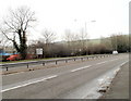
9
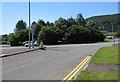
Trees on an A4119 roundabout, Llantrisant
On the east side of the roundabout in the middle of the A4119 Ely Valley Road, viewed from Heol-y-Sarn.
Image: © Jaggery
Taken: 17 Jun 2017
0.19 miles
10
River Ely downstream, Ynysmaerdy
The view downstream from a footbridge http://www.geograph.org.uk/photo/2263788 linking the Royal Glamorgan Hospital car park with the hospital buildings.
Image: © Jaggery
Taken: 9 Feb 2011
0.19 miles