1
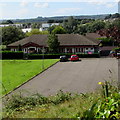
Chartist Road, Talbot Green
The north side of Chartist Road, an area of houses south of Talbot Road.
Image: © Jaggery
Taken: 31 Aug 2017
0.03 miles
2
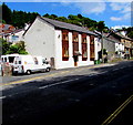
Dual carriageway A4119 through Talbot Green
Towards Penygawsi from the corner of Talbot Road. Talbot Green Shopping Park
is in the background where one of the names in view is Argos.
Image: © Jaggery
Taken: 31 Aug 2017
0.05 miles
3
Llantrisant Feel Good Factory, Llantrisant
Located in the Old Nursery below Talbot Road, Llantrisant Feel Good Factory is a privately-run business where power-assisted exercise equipment can be used. For people who don't want to join a gym, either because of their physical condition or their age, Llantrisant Feel Good Factory is a way to exercise, improve well-being and health. In addition to toning equipment, there is also a complementary therapy room here.
Image: © Jaggery
Taken: 31 Aug 2017
0.05 miles
4
Talbot Road houses, Talbot Green
On the north side of the B4595 Talbot Road on the ascent from Talbot Green to Llantrisant.
Image: © Jaggery
Taken: 31 Aug 2017
0.06 miles
5
Crossroads between Talbot Green and Llantrisant
Image: © Mick Lobb
Taken: 25 Sep 2008
0.07 miles
6
Ordnance Survey Cut Mark
This OS cut mark can be found on the wall NW side of Talbot Road. It marks a point 74.996m above mean sea level.
Image: © Adrian Dust
Taken: 19 Sep 2021
0.07 miles
7
Welcome to Talbot Green/Croeso i Tonysguboriau
Facing Llantrisant alongside the B4595 Talbot Road,
the bilingual sign shows that Talbot Green is Tonysguboriau in Welsh.
Image: © Jaggery
Taken: 31 Aug 2017
0.07 miles
8
Directions on the approach to Talbot Green
Facing Llantrisant alongside the B4595 Talbot Road.
The Talbot Green/Tonysguboriau boundary sign http://www.geograph.org.uk/photo/5520887 is in the background.
Image: © Jaggery
Taken: 31 Aug 2017
0.07 miles
9
Talbot Road semis, Talbot Green
Six semi-detached houses on the north side of the B4595 Talbot Road,
located between Talbot Close and the A4119 Ely Valley Road (ahead).
Image: © Jaggery
Taken: 31 Aug 2017
0.08 miles
10
Talbot Green in the snow
Taken from Ceridwen Terrace, Old Llantrisant. The shops of the retail park can be seen in the right of the picture, with Tesco on the left.
Image: © Mark Hopkins
Taken: 12 Feb 2006
0.09 miles


