IMAGES TAKEN NEAR TO
Llys Derwen, PONTYCLUN, CF72 8PZ
Introduction
This page details the photographs taken nearby to Llys Derwen, CF72 8PZ by members of the Geograph project.
The Geograph project started in 2005 with the aim of publishing, organising and preserving representative images for every square kilometre of Great Britain, Ireland and the Isle of Man.

There are currently over 7.5m images from over14,400 individuals and you can help contribute to the project by visiting https://www.geograph.org.uk
Image Map
Images are licensed for reuse under creativecommons.org/licenses/by-sa/2.0
Notes
- Clicking on the map will re-center to the selected point.
- The higher the marker number, the further away the image location is from the centre of the postcode.
Image Listing (38 Images Found)
Images are licensed for reuse under creativecommons.org/licenses/by-sa/2.0
Image
Details
Distance
3
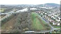
Maesaraul Junction
An aerial view of the site of Maesaraul Junction on the Ely Valley's Mwyndy Branch. From here the broad gauge GWR mixed with the standard (narrow) gauge of the Llantrisant & Taff Vale Junction Railway. More details at
https://tinyurl.com/r7pnzajn
Image: © Trevor Edward Streeter
Taken: 21 Feb 2021
0.10 miles
4
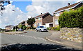
Burgesse Crescent houses, Llantrisant
Viewed from the corner of Cardiff Road. Burgesse Crescent leads to Despenser Avenue and Portreeve Close.
Image: © Jaggery
Taken: 31 Aug 2017
0.11 miles
5

Tesco Extra
The 24 hour supermarket at Talbot Green on a wet day.
Image: © Chris Thomas-Atkin
Taken: 5 Apr 2019
0.14 miles
6
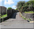
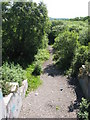
Public footpath on the west side of Cardiff Road, Llantrisant
From Cardiff Road to Burgesse Crescent. A small public footpath sign is on the lamppost.
Image: © Jaggery
Taken: 31 Aug 2017
0.14 miles
7
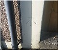
Ordnance Survey Cut Mark
This OS cut mark can be found on No46 Cardiff Road. It marks a point 66.330m above mean sea level.
Image: © Adrian Dust
Taken: 19 Sep 2021
0.14 miles
8
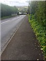
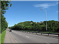
Llantrisant to Miskin road
Old road from Llantrisant to Miskin.
Image: © Alan Hughes
Taken: 25 Apr 2018
0.15 miles
9
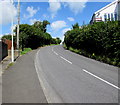
Bend in Cardiff Road, Llantrisant
This way to Llantrisant town centre, about 600 metres ahead.
Image: © Jaggery
Taken: 31 Aug 2017
0.15 miles
10
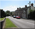
Row of four houses, Cardiff Road, Llantrisant
Numbers 46, 48, 50, 52 Cardiff Road.
Image: © Jaggery
Taken: 31 Aug 2017
0.15 miles