IMAGES TAKEN NEAR TO
Tan Yr Allt, PONTYCLUN, CF72 8PY
Introduction
This page details the photographs taken nearby to Tan Yr Allt, CF72 8PY by members of the Geograph project.
The Geograph project started in 2005 with the aim of publishing, organising and preserving representative images for every square kilometre of Great Britain, Ireland and the Isle of Man.

There are currently over 7.5m images from over14,400 individuals and you can help contribute to the project by visiting https://www.geograph.org.uk
Image Map
Images are licensed for reuse under creativecommons.org/licenses/by-sa/2.0
Notes
- Clicking on the map will re-center to the selected point.
- The higher the marker number, the further away the image location is from the centre of the postcode.
Image Listing (40 Images Found)
Images are licensed for reuse under creativecommons.org/licenses/by-sa/2.0
Image
Details
Distance
1
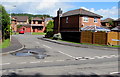
Tan-yr-allt, Llantrisant
Cul-de-sac on the north side of Main Road.
Image: © Jaggery
Taken: 31 Aug 2017
0.01 miles
2
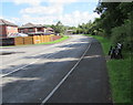
Roadside bench opposite Tan-yr-allt, Llantrisant
Alongside Main Road opposite Tan-yr-Allt. http://www.geograph.org.uk/photo/5521907
Image: © Jaggery
Taken: 31 Aug 2017
0.02 miles
3
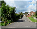
The Brambles, Llantrisant
Cul-de-sac on the west side of Main Road.
Image: © Jaggery
Taken: 31 Aug 2017
0.03 miles
4
Maesaraul Junction
Following the old Railway, lastly known as Cwm Colliery Line, we reach the Junction of the route to Mwyndy and that to Cwm and originally to Pontypridd. More descriptive details are contained in the blog-post about the route.
https://tinyurl.com/r7pnzajn
Image: © Trevor Edward Streeter
Taken: 10 Feb 2021
0.04 miles
5

Taff Cottages, Penygawsi
Formerly a busy main road, now a minor road leading to Cefn-y-Parc Cemetery. The new A473 road bridge can be seen in the background.
Image: © Duncan and Gareth Alderson
Taken: 15 Jun 2008
0.05 miles
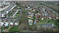
6
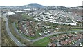
Llantrisant, with its former Railways in the foreground
This is an aerial survey of the remnants of the old Railway between Llantrisant (now called Pont-y-clun) station and the workings at Mwyndy.
https://tinyurl.com/r7pnzajn
Image: © Trevor Edward Streeter
Taken: 21 Feb 2021
0.05 miles
7
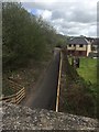
Disused railway line
View from old railway bridge of the disused line from Llantrisant to Pontyclun.
Image: © Alan Hughes
Taken: 25 Apr 2018
0.06 miles
8
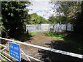
Gas installation near Main Road, Llantrisant
Inside a fenced enclosure set back 30 metres from the north side of Main Road.
Image: © Jaggery
Taken: 31 Aug 2017
0.06 miles
9
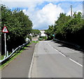
Warning sign - road narrows, Cardiff Road, Llantrisant
On the approach to this http://www.geograph.org.uk/photo/5521966 bridge.
Image: © Jaggery
Taken: 31 Aug 2017
0.07 miles
10
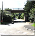
A473 overbridge, Llantrisant
The bridge carries the A473 over an unnamed dead-end
road on the south side of the corner of Cardiff Road and Main Road.
Image: © Jaggery
Taken: 31 Aug 2017
0.08 miles