IMAGES TAKEN NEAR TO
Llantrisant Road, PONTYCLUN, CF72 8NH
Introduction
This page details the photographs taken nearby to Llantrisant Road, CF72 8NH by members of the Geograph project.
The Geograph project started in 2005 with the aim of publishing, organising and preserving representative images for every square kilometre of Great Britain, Ireland and the Isle of Man.

There are currently over 7.5m images from over14,400 individuals and you can help contribute to the project by visiting https://www.geograph.org.uk
Image Map
Images are licensed for reuse under creativecommons.org/licenses/by-sa/2.0
Notes
- Clicking on the map will re-center to the selected point.
- The higher the marker number, the further away the image location is from the centre of the postcode.
Image Listing (6 Images Found)
Images are licensed for reuse under creativecommons.org/licenses/by-sa/2.0
Image
Details
Distance
2
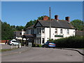
Castell Mynach
The Castell Mynach pub - the 'castle of the monks', referring to a nearby monastery.
Image: © Alan Hughes
Taken: 15 Feb 2016
0.01 miles
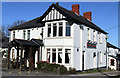
3
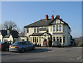
Castle Mynach Public House.
The Castle Mynach is a well known South Wales pub located on the A4119 just north of junction 34 of the M4.
Image: © Peter Wasp
Taken: 4 Apr 2007
0.01 miles

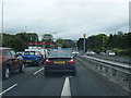
6
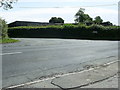
A4119 road junction near Groes-Faen
A road junction with the A4119 leading to Miskin and Pontyclun, the other into the country road for Miskin Manor Hotel.
Image: © Martyn Harries
Taken: 11 Jun 2011
0.23 miles