IMAGES TAKEN NEAR TO
The Paddocks, PONTYCLUN, CF72 8LE
Introduction
This page details the photographs taken nearby to The Paddocks, CF72 8LE by members of the Geograph project.
The Geograph project started in 2005 with the aim of publishing, organising and preserving representative images for every square kilometre of Great Britain, Ireland and the Isle of Man.

There are currently over 7.5m images from over14,400 individuals and you can help contribute to the project by visiting https://www.geograph.org.uk
Image Map
Images are licensed for reuse under creativecommons.org/licenses/by-sa/2.0
Notes
- Clicking on the map will re-center to the selected point.
- The higher the marker number, the further away the image location is from the centre of the postcode.
Image Listing (53 Images Found)
Images are licensed for reuse under creativecommons.org/licenses/by-sa/2.0
Image
Details
Distance
1
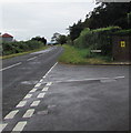
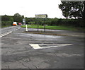
Yellow notice on a Groesfaen corner wall
The notice on the corner of The Paddocks and Peterson Road states This is a NEIGHBOURHOOD WATCH area.
Image: © Jaggery
Taken: 29 Aug 2017
0.02 miles
2
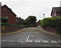
The Paddocks, Groesfaen
Cul-de-sac on the northwest side of Peterston Road.
Image: © Jaggery
Taken: 29 Aug 2017
0.02 miles
3
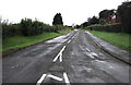
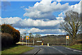
Peterston Road, Groesfaen
Viewed from the A4119 junction where a sign http://www.geograph.org.uk/photo/5525597 shows that Peterston-Super-Ely is three and a half miles ahead.
Image: © Jaggery
Taken: 29 Aug 2017
0.02 miles
5
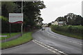
Rhondda Cynon Taf boundary sign, Groesfaen
The county borough boundary sign faces the A4119 on the corner of Peterston Road in Groesfaen.
The City and County of Cardiff boundary sign http://www.geograph.org.uk/photo/5525000 is behind the camera.
Image: © Jaggery
Taken: 29 Aug 2017
0.03 miles
6
Peterston-Super-Ely direction and distance sign, Groesfaen
The sign facing the A4119 points along this http://www.geograph.org.uk/photo/5525587 road.
Image: © Jaggery
Taken: 29 Aug 2017
0.04 miles
7
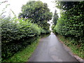
Green part of Peterston Road, Groesfaen
Southeast of Church Cottage. http://www.geograph.org.uk/photo/5517937
Image: © Jaggery
Taken: 29 Aug 2017
0.05 miles
9
A4119 directions and distances sign, Groesfaen
The sign alongside the A4119 faces Peterston Road 3 miles from Llantrisant and 8 miles from Cardiff (city centre).
Image: © Jaggery
Taken: 29 Aug 2017
0.05 miles