IMAGES TAKEN NEAR TO
Hensol Road, PONTYCLUN, CF72 8JW
Introduction
This page details the photographs taken nearby to Hensol Road, CF72 8JW by members of the Geograph project.
The Geograph project started in 2005 with the aim of publishing, organising and preserving representative images for every square kilometre of Great Britain, Ireland and the Isle of Man.

There are currently over 7.5m images from over14,400 individuals and you can help contribute to the project by visiting https://www.geograph.org.uk
Image Map
Images are licensed for reuse under creativecommons.org/licenses/by-sa/2.0
Notes
- Clicking on the map will re-center to the selected point.
- The higher the marker number, the further away the image location is from the centre of the postcode.
Image Listing (16 Images Found)
Images are licensed for reuse under creativecommons.org/licenses/by-sa/2.0
Image
Details
Distance
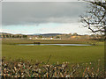
3

Line of trees
A line of trees fringes the northern edge of a field at Pantaquesta Farm.
Image: © Alan Hughes
Taken: 30 Nov 2017
0.09 miles
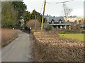
6
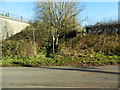
Sign and stile to footpath beside the M4, Miskin
Image: © John Lord
Taken: 1 Dec 2017
0.12 miles
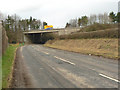
7
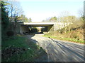
Bridge carrying the M4 over the Hensol to Miskin road
Image: © John Lord
Taken: 1 Dec 2017
0.13 miles
8

Rhondda Cynon Taf : M4 Motorway
The M4 Motorway heading west through Rhondda Cynon Taf.
Image: © Lewis Clarke
Taken: 10 Apr 2014
0.14 miles
9
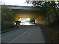
Bridge carrying the M4 over the Miskin to Hensol road
Image: © John Lord
Taken: 1 Dec 2017
0.15 miles
10
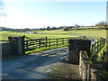
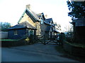
Gate and track to Pantyquesta Farm, Miskin
Image: © John Lord
Taken: 1 Dec 2017
0.15 miles