IMAGES TAKEN NEAR TO
Miskin, PONTYCLUN, CF72 8JR
Introduction
This page details the photographs taken nearby to CF72 8JR by members of the Geograph project.
The Geograph project started in 2005 with the aim of publishing, organising and preserving representative images for every square kilometre of Great Britain, Ireland and the Isle of Man.

There are currently over 7.5m images from over14,400 individuals and you can help contribute to the project by visiting https://www.geograph.org.uk
Image Map
Images are licensed for reuse under creativecommons.org/licenses/by-sa/2.0
Notes
- Clicking on the map will re-center to the selected point.
- The higher the marker number, the further away the image location is from the centre of the postcode.
Image Listing (63 Images Found)
Images are licensed for reuse under creativecommons.org/licenses/by-sa/2.0
Image
Details
Distance
1
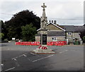
Miskin War Memorial
Crowned by a Celtic cross, the Grade II listed War Memorial
is in the centre of the village near St David's Church and the Miskin Arms.
Image: © Jaggery
Taken: 29 Aug 2017
0.02 miles
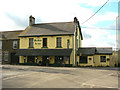
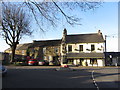
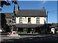
3
Grade II listed Miskin Arms, Miskin
Located in the centre of the village, near the War Memorial. http://www.geograph.org.uk/photo/5518178
The pub was built in the third quarter of the 19th century, first mentioned in 1871. Grade II listed in 2000.
Image: © Jaggery
Taken: 29 Aug 2017
0.03 miles
6
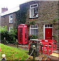
Grade II listed phonebox, Hensol Road, Miskin
The K6 type red box was Grade II listed in 2000.
Image: © Jaggery
Taken: 29 Aug 2017
0.03 miles
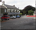
7
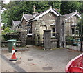
The Lodge, Hensol Road, Miskin
Stone building in the centre of the village.
Image: © Jaggery
Taken: 29 Aug 2017
0.04 miles
8
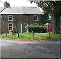
April Cottage, Hensol Road, Miskin
April Cottage is on the left.
Image: © Jaggery
Taken: 29 Aug 2017
0.04 miles
9
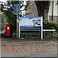
Information board in the centre of the village, Hensol Road, Miskin
With text in Welsh and English, and illustrations on the right, the board
gives a potted history of the village and details of local points of interest.
Image: © Jaggery
Taken: 29 Aug 2017
0.04 miles
10
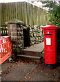
King George V pillarbox, Miskin
Located here. http://www.geograph.org.uk/photo/5518252 The GR on the box is short for Georgius Rex, Latin for King George,
in this case King George V who reigned from May 1910-January 1936.
Image: © Jaggery
Taken: 29 Aug 2017
0.04 miles