IMAGES TAKEN NEAR TO
Miskin, PONTYCLUN, CF72 8JQ
Introduction
This page details the photographs taken nearby to CF72 8JQ by members of the Geograph project.
The Geograph project started in 2005 with the aim of publishing, organising and preserving representative images for every square kilometre of Great Britain, Ireland and the Isle of Man.

There are currently over 7.5m images from over14,400 individuals and you can help contribute to the project by visiting https://www.geograph.org.uk
Image Map
Images are licensed for reuse under creativecommons.org/licenses/by-sa/2.0
Notes
- Clicking on the map will re-center to the selected point.
- The higher the marker number, the further away the image location is from the centre of the postcode.
Image Listing (62 Images Found)
Images are licensed for reuse under creativecommons.org/licenses/by-sa/2.0
Image
Details
Distance
1
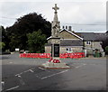
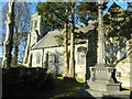
Miskin War Memorial
Crowned by a Celtic cross, the Grade II listed War Memorial
is in the centre of the village near St David's Church and the Miskin Arms.
Image: © Jaggery
Taken: 29 Aug 2017
0.04 miles
2
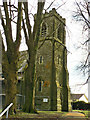
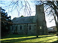
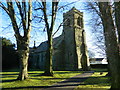
St David's Church, Miskin
Built in 1907 the church replaced a corrugated iron structure built in 1878.
Public donations, including profits of over £1,000 made at a Grand Fete at Miskin Manor, funded building costs and the church was licensed on 23rd December 1907 and later consecrated by Right Rev Timothy Rees, Bishop of Llandaff, on 23rd April 1933.
A main feature of the church is the beautiful stained-glass window dedicated to the Rhys-Williams family. Three most recent windows were designed following in the Pre-Raphaelite tradition by Jessie Bayes, a friend of William Morris, the architect, designer and writer who was one of the leaders of the Arts and Crafts Movement.
Image: © Mick Lobb
Taken: 10 Feb 2009
0.04 miles
3
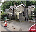
The Lodge, Hensol Road, Miskin
Stone building in the centre of the village.
Image: © Jaggery
Taken: 29 Aug 2017
0.04 miles
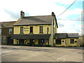
6
Grade II listed Miskin Arms, Miskin
Located in the centre of the village, near the War Memorial. http://www.geograph.org.uk/photo/5518178
The pub was built in the third quarter of the 19th century, first mentioned in 1871. Grade II listed in 2000.
Image: © Jaggery
Taken: 29 Aug 2017
0.04 miles
8
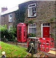
Grade II listed phonebox, Hensol Road, Miskin
The K6 type red box was Grade II listed in 2000.
Image: © Jaggery
Taken: 29 Aug 2017
0.05 miles
9
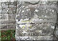
Ordnance Survey Cut Mark
This OS cut mark can be found on the south face of St David's Church. It marks a point 48.734m above mean sea level.
Image: © Adrian Dust
Taken: 19 Sep 2021
0.05 miles