IMAGES TAKEN NEAR TO
Maes Cefn Mabley, PONTYCLUN, CF72 8GA
Introduction
This page details the photographs taken nearby to Maes Cefn Mabley, CF72 8GA by members of the Geograph project.
The Geograph project started in 2005 with the aim of publishing, organising and preserving representative images for every square kilometre of Great Britain, Ireland and the Isle of Man.

There are currently over 7.5m images from over14,400 individuals and you can help contribute to the project by visiting https://www.geograph.org.uk
Image Map
Images are licensed for reuse under creativecommons.org/licenses/by-sa/2.0
Notes
- Clicking on the map will re-center to the selected point.
- The higher the marker number, the further away the image location is from the centre of the postcode.
Image Listing (28 Images Found)
Images are licensed for reuse under creativecommons.org/licenses/by-sa/2.0
Image
Details
Distance
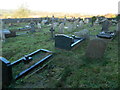
1
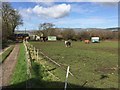
Horses in Paddock
Horses in a Paddock alongside a lane near Llantrisant.
Image: © Alan Hughes
Taken: 9 Mar 2017
0.13 miles
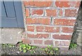
2
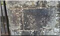
Ordnance Survey Cut Mark
This OS cut mark can be found on the gatepost of the Burial Ground on Heol y Sant. It marks a point 117.519m above mean sea level.
Image: © Adrian Dust
Taken: 19 Sep 2021
0.15 miles
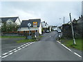
4
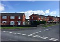
Dan Caerlan
Housing at Dan Caerlan, Llantrisant.
Image: © Alan Hughes
Taken: 9 Mar 2017
0.15 miles

6
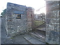
Entrance to Penuel Cemetery, Llantrisant
The plaque above the name-plate records the presence of American troops on the nearby Llantrisant Common during WWII.
Image: © John Lord
Taken: 25 Nov 2017
0.16 miles
7
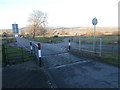
Cattle grid from Llantrisant on to Llantrisant Common
Image: © John Lord
Taken: 25 Nov 2017
0.16 miles
8
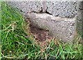
Ordnance Survey Cut Mark
Due to being buried only a small part of this cut mark can be seen on the wall west side of Heol y Sarn. It marks a point 131.043m above mean sea level.
Image: © Adrian Dust
Taken: 19 Sep 2021
0.16 miles
9
Ordnance Survey Cut Mark
This OS cut mark can be found on the wall of the Cross Keys PH on Commercial Street. It marks a point 132.555m above mean sea level.
Image: © Adrian Dust
Taken: 19 Sep 2021
0.16 miles