IMAGES TAKEN NEAR TO
Llys Y Tri Sant, CF72 8FS
Introduction
This page details the photographs taken nearby to Llys Y Tri Sant, CF72 8FS by members of the Geograph project.
The Geograph project started in 2005 with the aim of publishing, organising and preserving representative images for every square kilometre of Great Britain, Ireland and the Isle of Man.

There are currently over 7.5m images from over14,400 individuals and you can help contribute to the project by visiting https://www.geograph.org.uk
Image Map
Images are licensed for reuse under creativecommons.org/licenses/by-sa/2.0
Notes
- Clicking on the map will re-center to the selected point.
- The higher the marker number, the further away the image location is from the centre of the postcode.
Image Listing (78 Images Found)
Images are licensed for reuse under creativecommons.org/licenses/by-sa/2.0
Image
Details
Distance
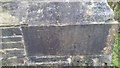
1
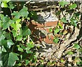
Ordnance Survey Rivet
This OS rivet can be found at the corner of the garage. It marks a point 130.735m above mean sea level.
Image: © Adrian Dust
Taken: 19 Sep 2021
0.03 miles
2

Red berries
Red berries in a country churchyard.
Image: © Alan Hughes
Taken: 18 Nov 2019
0.05 miles
3

Backlit cross
Tombstone cross backlit by the late afternoon sun.
Image: © Alan Hughes
Taken: 18 Nov 2019
0.06 miles
4
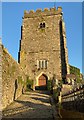
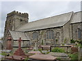
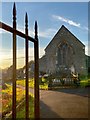
Parish Church of Llantrisant
Cobbled approach to Llantrisant Church.
Image: © Alan Hughes
Taken: 18 Nov 2019
0.06 miles
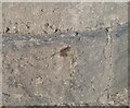
5
Ordnance Survey Cut Mark
This OS cut mark can be found on the north face of the Church. It marks a point 148.337m above mean sea level.
Image: © Adrian Dust
Taken: 20 Apr 2016
0.06 miles
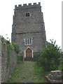
7
Llantrisant, Sts. Illtyd, Tyfodwg & Gwynno
Image: © Dave Kelly
Taken: 5 May 2015
0.07 miles
8
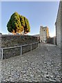
Cobbled street
Cobbled street leading from Swan Street to Llantrisant Parish Church.
Image: © Alan Hughes
Taken: 18 Nov 2019
0.07 miles
9
Ordnance Survey Cut Mark
This OS cut mark can be found on the wall SW side of Heol y Beiliau. It marks a point 111.429m above mean sea level.
Image: © Adrian Dust
Taken: 19 Sep 2021
0.08 miles
10
Un dau tri
Llantrisant - the church of three saints. Illtyd, Gwynno and Dyfodwg.
https://en.m.wikipedia.org/wiki/Llantrisant
Image: © Alan Hughes
Taken: 18 Nov 2019
0.08 miles