IMAGES TAKEN NEAR TO
Cwrt Tafarn, CF72 8FR
Introduction
This page details the photographs taken nearby to Cwrt Tafarn, CF72 8FR by members of the Geograph project.
The Geograph project started in 2005 with the aim of publishing, organising and preserving representative images for every square kilometre of Great Britain, Ireland and the Isle of Man.

There are currently over 7.5m images from over14,400 individuals and you can help contribute to the project by visiting https://www.geograph.org.uk
Image Map
Images are licensed for reuse under creativecommons.org/licenses/by-sa/2.0
Notes
- Clicking on the map will re-center to the selected point.
- The higher the marker number, the further away the image location is from the centre of the postcode.
Image Listing (75 Images Found)
Images are licensed for reuse under creativecommons.org/licenses/by-sa/2.0
Image
Details
Distance
1

Cross Inn boundary signs facing Llantrisant
Alongside Cross Inn Road. The Llantrisant boundary signs http://www.geograph.org.uk/photo/5520528 are on the backs of the Cross Inn signs.
Image: © Jaggery
Taken: 31 Aug 2017
0.04 miles
2
Llantrisant twinning information
The sign located here http://www.geograph.org.uk/photo/5520528 shows that Llantrisant is twinned with Crécy-en-Ponthieu, France.
The information is also in Welsh.
Image: © Jaggery
Taken: 31 Aug 2017
0.04 miles
3

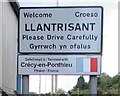
Eastern boundary of Llantrisant
The Welcome/Croeso signs are alongside Cross Inn Road facing Cross Inn.
The sign on the left http://www.geograph.org.uk/photo/5520534 shows that Llantrisant is twinned with Crécy-en-Ponthieu, France.
The Cross Inn boundary signs http://www.geograph.org.uk/photo/5520539 are on the backs of these signs.
Image: © Jaggery
Taken: 31 Aug 2017
0.04 miles
4

D J Llantrisant
Garage on the south side of Cross Inn Road, Llantrisant.
Image: © Jaggery
Taken: 31 Aug 2017
0.04 miles
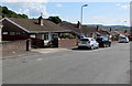
6

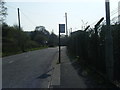
Summerfield Drive, Llantrisant
On the south side of Cross Inn Road.
Image: © Jaggery
Taken: 31 Aug 2017
0.08 miles
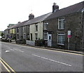
7
Cross Inn Road houses, Llantrisant
The houses on the south side of Cross Inn Road are opposite hedges.
Image: © Jaggery
Taken: 31 Aug 2017
0.08 miles
8
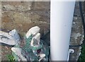
Ordnance Survey Cut Mark
This OS cut mark can be found on No8 Cross Inn Road. It marks a point 78.645m above mean sea level.
Image: © Adrian Dust
Taken: 19 Sep 2021
0.09 miles
9
Southgate Avenue bungalows, Llantrisant
Originally, bungalow was used in English for a lightly-built house, with a veranda and one storey.
In current UK usage it is a convenient word for any one-storey dwelling.
Image: © Jaggery
Taken: 31 Aug 2017
0.09 miles
10
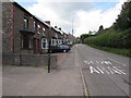
Row of houses, Cross Inn Road, Llantrisant
Viewed past a speed bump.
Image: © Jaggery
Taken: 31 Aug 2017
0.10 miles