IMAGES TAKEN NEAR TO
Ruperra Street, PONTYCLUN, CF72 8EZ
Introduction
This page details the photographs taken nearby to Ruperra Street, CF72 8EZ by members of the Geograph project.
The Geograph project started in 2005 with the aim of publishing, organising and preserving representative images for every square kilometre of Great Britain, Ireland and the Isle of Man.

There are currently over 7.5m images from over14,400 individuals and you can help contribute to the project by visiting https://www.geograph.org.uk
Image Map
Images are licensed for reuse under creativecommons.org/licenses/by-sa/2.0
Notes
- Clicking on the map will re-center to the selected point.
- The higher the marker number, the further away the image location is from the centre of the postcode.
Image Listing (52 Images Found)
Images are licensed for reuse under creativecommons.org/licenses/by-sa/2.0
Image
Details
Distance
1
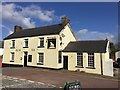
Ordnance Survey Cut Mark
This OS cut mark can be found on the wall of the Cross Keys PH on Commercial Street. It marks a point 132.555m above mean sea level.
Image: © Adrian Dust
Taken: 19 Sep 2021
0.06 miles
2
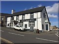
The Cross Keys
The Cross Keys, Llantrisant.
Image: © Alan Hughes
Taken: 9 Mar 2017
0.07 miles
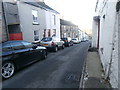
3
Cottages and Shops
A row of old cottages and shops in Llantrisant.
Image: © Alan Hughes
Taken: 9 Mar 2017
0.08 miles
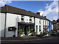
4

Pink Zebra
Shop in the centre of Llantrisant.
Image: © Alan Hughes
Taken: 18 Nov 2019
0.08 miles
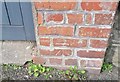
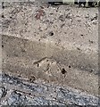
6
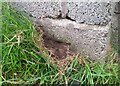
Ordnance Survey Cut Mark
Due to being buried only a small part of this cut mark can be seen on the wall west side of Heol y Sarn. It marks a point 131.043m above mean sea level.
Image: © Adrian Dust
Taken: 19 Sep 2021
0.08 miles
7
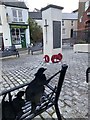
War memorial
War memorial in the Bullring, Llantrisant.
Image: © Alan Hughes
Taken: 18 Nov 2019
0.09 miles
8
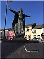
Dr.William Price
Surgeon, chartist and self-styled Druid.
Image: © Alan Hughes
Taken: 9 Mar 2017
0.09 miles
9
Ordnance Survey Rivet
This OS rivet can be found on the village pump. It marks a point 141.162m above mean sea level.
Image: © Adrian Dust
Taken: 20 Apr 2016
0.10 miles