IMAGES TAKEN NEAR TO
Heol Sticil-y-Beddau, PONTYCLUN, CF72 8BT
Introduction
This page details the photographs taken nearby to Heol Sticil-y-Beddau, CF72 8BT by members of the Geograph project.
The Geograph project started in 2005 with the aim of publishing, organising and preserving representative images for every square kilometre of Great Britain, Ireland and the Isle of Man.

There are currently over 7.5m images from over14,400 individuals and you can help contribute to the project by visiting https://www.geograph.org.uk
Image Map
Images are licensed for reuse under creativecommons.org/licenses/by-sa/2.0
Notes
- Clicking on the map will re-center to the selected point.
- The higher the marker number, the further away the image location is from the centre of the postcode.
Image Listing (89 Images Found)
Images are licensed for reuse under creativecommons.org/licenses/by-sa/2.0
Image
Details
Distance

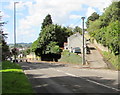
2
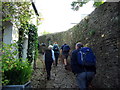
Heol Sticil y Beddau
Cerddwyr yn dringo hen ffordd gul o'r enw Heol Sticil y Beddau.
Walkers ascending an old narrow road called Heol Sticil y Beddau (trans. stile of the graves road)
Image: © Alan Richards
Taken: 21 Sep 2008
0.03 miles
3
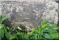
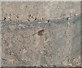
Ordnance Survey Cut Mark
This OS cut mark can be found on the gatepost of The Laurels on High Street. It marks a point 110.685m above mean sea level.
Image: © Adrian Dust
Taken: 19 Sep 2021
0.04 miles
4
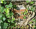
Ordnance Survey Cut Mark
This OS cut mark can be found on the wall SW side of Heol y Beiliau. It marks a point 111.429m above mean sea level.
Image: © Adrian Dust
Taken: 19 Sep 2021
0.04 miles
5
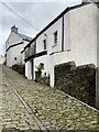
Yr Allt
A cobbled street in old Llantrisant.
Image: © Alan Hughes
Taken: 19 Nov 2019
0.06 miles
6
Ordnance Survey Rivet
This OS rivet can be found at the corner of the garage. It marks a point 130.735m above mean sea level.
Image: © Adrian Dust
Taken: 19 Sep 2021
0.06 miles
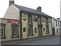
8
Insole Terrace, Llantrisant
On the right, Insole Terrace ascends westwards away from the B4595 Talbot Road.
Image: © Jaggery
Taken: 31 Aug 2017
0.07 miles
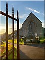
9

Backlit cross
Tombstone cross backlit by the late afternoon sun.
Image: © Alan Hughes
Taken: 18 Nov 2019
0.07 miles
10
Un dau tri
Llantrisant - the church of three saints. Illtyd, Gwynno and Dyfodwg.
https://en.m.wikipedia.org/wiki/Llantrisant
Image: © Alan Hughes
Taken: 18 Nov 2019
0.08 miles