IMAGES TAKEN NEAR TO
High Street, PONTYCLUN, CF72 8BS
Introduction
This page details the photographs taken nearby to High Street, CF72 8BS by members of the Geograph project.
The Geograph project started in 2005 with the aim of publishing, organising and preserving representative images for every square kilometre of Great Britain, Ireland and the Isle of Man.

There are currently over 7.5m images from over14,400 individuals and you can help contribute to the project by visiting https://www.geograph.org.uk
Image Map
Images are licensed for reuse under creativecommons.org/licenses/by-sa/2.0
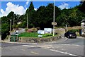
Notes
- Clicking on the map will re-center to the selected point.
- The higher the marker number, the further away the image location is from the centre of the postcode.
Image Listing (87 Images Found)
Images are licensed for reuse under creativecommons.org/licenses/by-sa/2.0
Image
Details
Distance
1
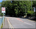
Hairpin bend in the B4595, Llantrisant
The car is ascending the B4595 High Street towards the town centre.
The B4595 on the left descends towards Talbot Green.
Image: © Jaggery
Taken: 31 Aug 2017
0.04 miles
2
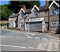
Shuttered shop at the SE end of High Street, Llantrisant
Closed and shuttered at 11:20 am on Thursday August 31st 2017.
Image: © Jaggery
Taken: 31 Aug 2017
0.04 miles
3
Talbot Road bus stops and shelters, Llantrisant
Alongside the B4595 Talbot Road near the corner of the B4595 High Street.
Talbot Road descends towards Talbot Green.
Image: © Jaggery
Taken: 31 Aug 2017
0.04 miles
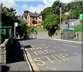
4
Talbot Road pelican crossing, Llantrisant
Across the B4595 Talbot Road on the descent from Llantrisant to Talbot Green.
Chambers Dictionary states that pelican in this context is adapted from "pedestrian light controlled crossing".
Image: © Jaggery
Taken: 31 Aug 2017
0.04 miles
5
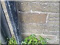
Ordnance Survey Cut Mark
This OS cut mark can be found on the wall of the Penuel Chapel on High Street. It marks a point 126.471m above mean sea level.
Image: © Adrian Dust
Taken: 19 Sep 2021
0.05 miles
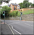
6
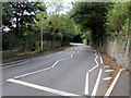
Zigzag markings on Talbot Road, Llantrisant
The white markings on the B4595 draw attention to this http://www.geograph.org.uk/photo/5533228 pelican crossing.
Image: © Jaggery
Taken: 31 Aug 2017
0.05 miles
7
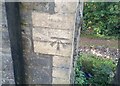
Ordnance Survey Cut Mark
This OS cut mark can be found on Parkview, the former Wesleyan Chapel, Talbot Road. It marks a point 94.583m above mean sea level.
Image: © Adrian Dust
Taken: 19 Sep 2021
0.06 miles
8
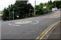
Mini-roundabout in Llantrisant
At the junction of Cross Inn Road and Cardiff Road.
Image: © Jaggery
Taken: 31 Aug 2017
0.07 miles
9
Warning sign - humps ahead to the left and right, Cardiff Road, Llantrisant
Facing northbound traffic on the approach to the Cross Inn Road junction.
Twmpathau is Welsh for Humps.
Image: © Jaggery
Taken: 31 Aug 2017
0.07 miles
10
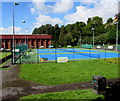
Lawn tennis courts, Llantrisant
On the northeast side of Llantrisant Leisure Centre.
Image: © Jaggery
Taken: 31 Aug 2017
0.08 miles