IMAGES TAKEN NEAR TO
Main Road, PONTYCLUN, CF72 8AZ
Introduction
This page details the photographs taken nearby to Main Road, CF72 8AZ by members of the Geograph project.
The Geograph project started in 2005 with the aim of publishing, organising and preserving representative images for every square kilometre of Great Britain, Ireland and the Isle of Man.

There are currently over 7.5m images from over14,400 individuals and you can help contribute to the project by visiting https://www.geograph.org.uk
Image Map
Images are licensed for reuse under creativecommons.org/licenses/by-sa/2.0
Notes
- Clicking on the map will re-center to the selected point.
- The higher the marker number, the further away the image location is from the centre of the postcode.
Image Listing (39 Images Found)
Images are licensed for reuse under creativecommons.org/licenses/by-sa/2.0
Image
Details
Distance
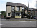
1
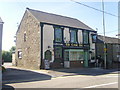
The Cross Inn, Cross Inn, Llantrisant
The hamlet of Cross Inn is situated one mile from Llantrisant.
Image: © Duncan and Gareth Alderson
Taken: 8 Jun 2008
0.02 miles
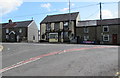
2
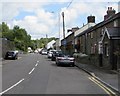
Main Road, Cross Inn near Llantrisant
Formerly a through route ahead, Main Road has been a dead end since the creation
of the current route of the A473. Cross Inn railway station was formerly nearby.
Image: © Jaggery
Taken: 31 Aug 2017
0.02 miles
3
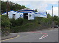
Southgate Garage (Llantrisant) Ltd, Cross Inn
Located in Old Station Yard above the corner of Main Road and Cross Inn Road.
Image: © Jaggery
Taken: 31 Aug 2017
0.05 miles
5
The Cross Inn, Main Road, Cross Inn near Llantrisant
http://www.geograph.org.uk/photo/5520501 to a broader view.
Image: © Jaggery
Taken: 31 Aug 2017
0.05 miles
6
The Cross Inn, Main Road, Cross Inn near Llantrisant
The Cross Inn pub in Cross Inn near the southeast edge of Llantrisant, viewed from Cross Inn Road.
http://www.geograph.org.uk/photo/5520503 to a closer view.
Image: © Jaggery
Taken: 31 Aug 2017
0.05 miles
7
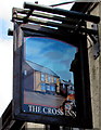
Cross Inn name sign near Llantrisant
Hanging from a wall bracket here. http://www.geograph.org.uk/photo/5520503
Image: © Jaggery
Taken: 31 Aug 2017
0.06 miles
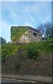
8
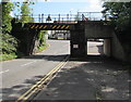
Northwest side of Cross Inn Road bridge, Cross Inn near Llantrisant
The bridge formerly carried the railway near Cross Inn railway station.
Station and railway have both gone. Headroom shown is 12' 3".
The Cross Inn pub http://www.geograph.org.uk/photo/5520503 is in the background.
Image: © Jaggery
Taken: 31 Aug 2017
0.06 miles
9
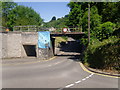
Railway bridge and road junction, Cross Inn
The road ahead leads uphill to Llantrisant. The railway line has been disused for several years. There have been many incidents of high vehicles getting stuck or striking the bridge, but as there is the possibility of the passenger service being re-instated the bridge has not been dismantled.
Image: © Duncan and Gareth Alderson
Taken: 8 Jun 2008
0.06 miles
10
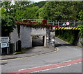
Underpass and bridge, Cross Inn Road, Cross Inn
The bridge formerly carried the railway near Cross Inn railway station.
Station and railway have both gone. Headroom shown is 12' 3"
A pedestrian underpass is on the left.
Image: © Jaggery
Taken: 31 Aug 2017
0.06 miles