
IMAGES TAKEN NEAR TO
Heol Yr Alarch, CF72 4AR
Introduction
This page details the photographs taken nearby to Heol Yr Alarch, CF72 4AR by members of the Geograph project.
The Geograph project started in 2005 with the aim of publishing, organising and preserving representative images for every square kilometre of Great Britain, Ireland and the Isle of Man.

There are currently over 7.5m images from over14,400 individuals and you can help contribute to the project by visiting https://www.geograph.org.uk
Image Map
Images are licensed for reuse under creativecommons.org/licenses/by-sa/2.0
Notes
- Clicking on the map will re-center to the selected point.
- The higher the marker number, the further away the image location is from the centre of the postcode.
Image Listing (6 Images Found)
Images are licensed for reuse under creativecommons.org/licenses/by-sa/2.0
Image
Details
Distance
1

Llanilid Former Opencast
Part of the restored opencast site, now under redevelopment. The foundations for a new bypass can be seen at the extreme right.
Image: © Paul Roberts
Taken: 14 Mar 2007
0.11 miles
2
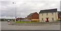
New Estate
New houses on the southern edge of Llanharan.
Image: © Colin Bews
Taken: 9 Aug 2014
0.18 miles
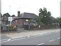
4
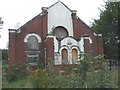
Derelict chapel, Bryncae
There is a funeral director's office at the rear of this chapel
Image: © John Lord
Taken: 27 Aug 2008
0.24 miles
5
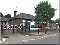
Ysgol Gynradd Dolau
Dolau Junior. School.
Image: © Alan Hughes
Taken: 31 May 2017
0.25 miles
6
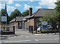
Entrance to Dolau Primary School, Llanharan
On the south side of the A473 Bridgend Road.
Image: © Jaggery
Taken: 19 Jun 2014
0.25 miles