1
Leekes of Llantrisant
Leekes department store at Llantrisant.
Image: © Alan Hughes
Taken: 30 Sep 2016
0.09 miles
2
Entrance to Y Pant School
Image: © John Lord
Taken: 1 Dec 2017
0.10 miles
3
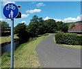
Riverside footpath and cycleway, Pontyclun
From the street named Ynysddu, the route along a bank of the River
Ely heads west towards Coedely (3 miles) and Tonyrefail (5 miles).
Image: © Jaggery
Taken: 5 Jun 2014
0.16 miles
4
Level Crossing A473, Talbot Green
Disused Railway line, Pontyclun to Pontypridd.
Image: © Duncan and Gareth Alderson
Taken: 15 Jun 2008
0.16 miles
5
Footpath beside the Afon Clun, Pontyclun
Image: © John Lord
Taken: 1 Dec 2017
0.17 miles
6
Level crossing on the A473 near Pontyclun
Not likely to be used again any time soon, as the rails to the north (right) have been lifted, and those to the south are very overgrown.
Image: © Gareth James
Taken: 4 Jun 2011
0.17 miles
7
Level crossing on the A473 near Pontyclun
The branch line from Cwm Coke works has mostly been lifted. Here, the rails remain in the road, but the track beyond is severely overgrown.
Image: © Gareth James
Taken: 4 Jun 2011
0.17 miles
8
Disused railway crosses the footpath beside the A473, and disappears into the undergrowth
Image: © John Lord
Taken: 1 Dec 2017
0.17 miles
9
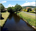
Upstream along the Ely, Pontyclun
The Ely River (Afon Elai in Welsh) flows towards this http://www.geograph.org.uk/photo/4499303 bridge. About 30 metres
behind the bridge, its waters are augmented at the confluence http://www.geograph.org.uk/photo/4499323 with the Afon Clun.
Image: © Jaggery
Taken: 5 Jun 2014
0.17 miles
10
Footpath beside the Afon Clun, Pontyclun
Image: © John Lord
Taken: 1 Dec 2017
0.17 miles


