IMAGES TAKEN NEAR TO
Ty Mawr Close, COWBRIDGE, CF71 7TD
Introduction
This page details the photographs taken nearby to Ty Mawr Close, CF71 7TD by members of the Geograph project.
The Geograph project started in 2005 with the aim of publishing, organising and preserving representative images for every square kilometre of Great Britain, Ireland and the Isle of Man.

There are currently over 7.5m images from over14,400 individuals and you can help contribute to the project by visiting https://www.geograph.org.uk
Image Map
Images are licensed for reuse under creativecommons.org/licenses/by-sa/2.0
Notes
- Clicking on the map will re-center to the selected point.
- The higher the marker number, the further away the image location is from the centre of the postcode.
Image Listing (18 Images Found)
Images are licensed for reuse under creativecommons.org/licenses/by-sa/2.0
Image
Details
Distance

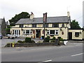
5

The White Lion, Ystradowen
The White Lion, scheduled to reopen as The Meadow Vale in September 2017.
Image: © Alan Hughes
Taken: 12 Jun 2017
0.07 miles
7
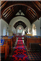
St. Owain's Church Interior
There is a photo of the Church font at Image
Image: © Guy Butler-Madden
Taken: 29 Jan 2010
0.08 miles
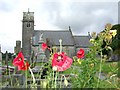
8
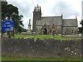
St.Owain's Church
St.Owain's Church, Ystradowen.
Image: © Alan Hughes
Taken: 12 Jun 2017
0.08 miles
9
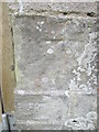
Ordnance Survey Cut Mark
This OS cut mark can be found on the NW face of St Owain's Church. It marks a point 68.607m above mean sea level.
Image: © Adrian Dust
Taken: 9 Apr 2016
0.09 miles
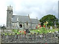
10
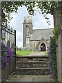
St.Owain's Church
View of St.Owain's Church through the porch.
Image: © Alan Hughes
Taken: 12 Jun 2017
0.09 miles