IMAGES TAKEN NEAR TO
Pentre Meyrick, COWBRIDGE, CF71 7RN
Introduction
This page details the photographs taken nearby to CF71 7RN by members of the Geograph project.
The Geograph project started in 2005 with the aim of publishing, organising and preserving representative images for every square kilometre of Great Britain, Ireland and the Isle of Man.

There are currently over 7.5m images from over14,400 individuals and you can help contribute to the project by visiting https://www.geograph.org.uk
Image Map (Loading...)


Getting Data...Please wait
Leaflet Map data © OpenStreetMap
Images are licensed for reuse under creativecommons.org/licenses/by-sa/2.0
Notes
- Clicking on the map will re-center to the selected point.
- The higher the marker number, the further away the image location is from the centre of the postcode.
Image Listing (8 Images Found)
Images are licensed for reuse under creativecommons.org/licenses/by-sa/2.0
Image
Details
Distance
1
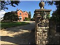
Pentre Meyrick House
Pentre Meyrick house.
Image: © Alan Hughes
Taken: 3 Oct 2016
0.04 miles
3
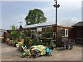
Cross Farm
Garden centre at Cross Farm, Pentre Meurig.
Image: © Alan Hughes
Taken: 6 Jun 2016
0.12 miles
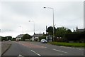
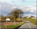
4
Road approaching Pentre Meyrick from the north
Image: © Colin Pyle
Taken: 25 May 2011
0.14 miles
5
Ordnance Survey Rivet
This OS rivet can be found on the lowest step of the stile. It marks a point 87.877m above mean sea level.
Image: © Adrian Dust
Taken: 20 May 2018
0.16 miles
7

Field of Daffodils - Pentre Meyrick
Well developed now with only a small number harvested. There is a nursery across the road from the field so perhaps these will remain for harvesting of their bulbs.
Image: © Mick Lobb
Taken: 18 Apr 2009
0.19 miles
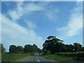
8
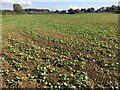
Winter Crop
Early signs of growth on a newly planted winter crop of (probably) mangolds. Near Pentre Meyrick.
Image: © Alan Hughes
Taken: 3 Oct 2016
0.25 miles