IMAGES TAKEN NEAR TO
Heol Y Nant, COWBRIDGE, CF71 7PE
Introduction
This page details the photographs taken nearby to Heol Y Nant, CF71 7PE by members of the Geograph project.
The Geograph project started in 2005 with the aim of publishing, organising and preserving representative images for every square kilometre of Great Britain, Ireland and the Isle of Man.

There are currently over 7.5m images from over14,400 individuals and you can help contribute to the project by visiting https://www.geograph.org.uk
Image Map (Loading...)


Getting Data...Please wait
Leaflet Map data © OpenStreetMap
Images are licensed for reuse under creativecommons.org/licenses/by-sa/2.0
Notes
- Clicking on the map will re-center to the selected point.
- The higher the marker number, the further away the image location is from the centre of the postcode.
Image Listing (31 Images Found)
Images are licensed for reuse under creativecommons.org/licenses/by-sa/2.0
Image
Details
Distance
1
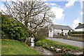
Llandow Brook and Heol-Y-Nant
The water in the brook at this point was still when the picture was taken in mid-September 2024, a consequence, perhaps, of a fairly dry summer. A little to the east, but still within the village, there wasn’t any water at all in the channel beside the road.
Image: © eswales
Taken: 16 Sep 2024
0.04 miles
2
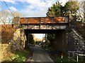
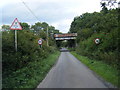
Railway Bridge at Llandow
Railway bridge over road leading into Llandow.
Image: © Alan Hughes
Taken: 29 Dec 2015
0.05 miles
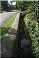
3
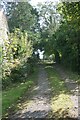
Access track for public footpath to Sutton, Llandow
Not signed on the ground, but shown on OpenStreetMap. A stile to the right (west) of the track near its end takes you onto the public footpath in the field seen in Image
Image: © eswales
Taken: 16 Sep 2024
0.05 miles
5

Ordnance Survey Cut Mark
This OS cut mark can be found on the NW buttress of the railway bridge. It marks a point 55.373m above mean sea level.
Image: © Adrian Dust
Taken: 1 Sep 2021
0.05 miles
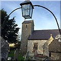
6
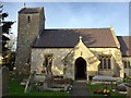
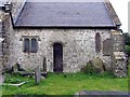
Holy Trinity Church, Llandow
Parish Church of the Holy Trinity, Llandow.
Image: © Alan Hughes
Taken: 29 Dec 2015
0.06 miles
7
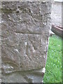
Ordnance Survey Cut Mark
This OS cut mark can be found on the SW face of Holy Trinity Church. It marks a point 54.041m above mean sea level.
Image: © Adrian Dust
Taken: 9 Apr 2016
0.06 miles
8
Entrance to Holy Trinity Church
Entrance to Holy Trinity Church, Llandow.
Image: © Alan Hughes
Taken: 29 Dec 2015
0.06 miles