IMAGES TAKEN NEAR TO
Nash, COWBRIDGE, CF71 7NS
Introduction
This page details the photographs taken nearby to CF71 7NS by members of the Geograph project.
The Geograph project started in 2005 with the aim of publishing, organising and preserving representative images for every square kilometre of Great Britain, Ireland and the Isle of Man.

There are currently over 7.5m images from over14,400 individuals and you can help contribute to the project by visiting https://www.geograph.org.uk
Image Map
Images are licensed for reuse under creativecommons.org/licenses/by-sa/2.0
Notes
- Clicking on the map will re-center to the selected point.
- The higher the marker number, the further away the image location is from the centre of the postcode.
Image Listing (3 Images Found)
Images are licensed for reuse under creativecommons.org/licenses/by-sa/2.0
Image
Details
Distance
1
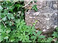
Ordnance Survey Cut Mark
This OS cut mark can be found on the wall SE side of the road. It marks a point 92.638m above mean sea level.
Image: © Adrian Dust
Taken: 1 Sep 2021
0.13 miles
3
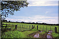
Gateway - Llandow
Just above the gate on the left the arched roof line of a hangar can be seen jutting above the hedgerow. This currently houses a furniture store. One of many usages of the old airfield's hangars.
Image: © Mick Lobb
Taken: 5 Aug 2009
0.25 miles