IMAGES TAKEN NEAR TO
Middlegate Walk, COWBRIDGE, CF71 7LA
Introduction
This page details the photographs taken nearby to Middlegate Walk, CF71 7LA by members of the Geograph project.
The Geograph project started in 2005 with the aim of publishing, organising and preserving representative images for every square kilometre of Great Britain, Ireland and the Isle of Man.

There are currently over 7.5m images from over14,400 individuals and you can help contribute to the project by visiting https://www.geograph.org.uk
Image Map
Images are licensed for reuse under creativecommons.org/licenses/by-sa/2.0
Notes
- Clicking on the map will re-center to the selected point.
- The higher the marker number, the further away the image location is from the centre of the postcode.
Image Listing (136 Images Found)
Images are licensed for reuse under creativecommons.org/licenses/by-sa/2.0
Image
Details
Distance
1
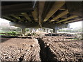
Cowbridge by-pass viaduct
... from underneath.
Image: © Gareth James
Taken: 17 Jan 2010
0.09 miles
2
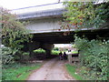
O dan yr A48 / Under the A48
Cerddwyr yn dilyn llwybr cyhoeddus o dan ffordd osgoi y Bontfaen.
Walkers following a public footpath below the Cowbridge bypass.
Image: © Alan Richards
Taken: 18 Oct 2015
0.09 miles
3

Cowbridge Health Centre
The purpose-built health centre is located near the leisure centre http://www.geograph.org.uk/photo/3667340 in The Broad Shoard.
Image: © Jaggery
Taken: 19 Jan 2012
0.10 miles
4
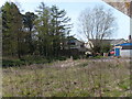
Copse on banks of River Thaw
View from carpark across disused allotment next to former British Legion club.
Image: © Ron Speed
Taken: 6 Apr 2009
0.10 miles
6
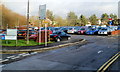
Town Hall car park, Cowbridge
Located north of the town hall and east of Middlegate Court.
Arrows direct drivers to the long term and short term areas of the car park.
Image: © Jaggery
Taken: 19 Jan 2012
0.12 miles
7
Welsh medium nursery school in Cowbridge
Located in The Broad Shoard near the Health Centre, http://www.geograph.org.uk/photo/3667350 Cylch Meithrin Y Bont-faen is a Welsh language nursery for pre-school children aged at least 2.
Image: © Jaggery
Taken: 19 Jan 2012
0.12 miles
8
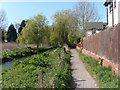
River walk
River walk leading to townhall carpark
Image: © Ron Speed
Taken: 12 Apr 2009
0.13 miles
9
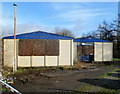
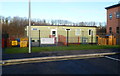
Boarded-up former Royal British Legion club, Cowbridge
The derelict building is on the south side of Town Hall car park. http://www.geograph.org.uk/photo/3446413
Image: © Jaggery
Taken: 19 Jan 2012
0.13 miles
10
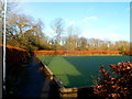
Cowbridge bowling green
Part of Cowbridge Bowling Club, located in The Broad Shoard.
Image: © Jaggery
Taken: 19 Jan 2012
0.13 miles