IMAGES TAKEN NEAR TO
Llanmihangel Road, COWBRIDGE, CF71 7JY
Introduction
This page details the photographs taken nearby to Llanmihangel Road, CF71 7JY by members of the Geograph project.
The Geograph project started in 2005 with the aim of publishing, organising and preserving representative images for every square kilometre of Great Britain, Ireland and the Isle of Man.

There are currently over 7.5m images from over14,400 individuals and you can help contribute to the project by visiting https://www.geograph.org.uk
Image Map (7 Images)


Getting Data...Please wait
Leaflet Map data © OpenStreetMap
Images are licensed for reuse under creativecommons.org/licenses/by-sa/2.0
Notes
- Clicking on the map will re-center to the selected point.
- The higher the marker number, the further away the image location is from the centre of the postcode.
Image Listing (7 Images Found)
Images are licensed for reuse under creativecommons.org/licenses/by-sa/2.0
Image
Details
Distance
1
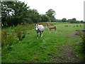
Pony and foal near Llanblethian
A pretty young foal with its mother.
Image: © Jeremy Bolwell
Taken: 7 Jul 2011
0.05 miles
2
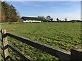
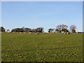
Newhouse Farm
Pasture at Newhouse Farm near Cowbridge.
Image: © Alan Hughes
Taken: 31 Oct 2016
0.16 miles
3
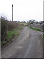
The road from Llandough to Cowbridge
The road to the castle branches off on the right.
Image: © HelenK
Taken: 22 Feb 2008
0.18 miles
4
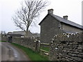
Farmhouse on road to Llandough
This is dry-stone wall country.
Image: © HelenK
Taken: 22 Feb 2008
0.21 miles
5
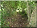
Sunken path between fields near Llanblethian
Another old field access path providing shade or shelter for field workers or locals getting about their locality in times past.
Image: © Jeremy Bolwell
Taken: 7 Jul 2011
0.21 miles
7
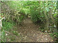
Sunken path near Llanblethian
A footpath follows an old routeway with origins as a field access path for workers tending crops, or even earlier origins lost in the mists of time.
Image: © Jeremy Bolwell
Taken: 7 Jul 2011
0.22 miles