IMAGES TAKEN NEAR TO
Porth-y-Green Close, COWBRIDGE, CF71 7JR
Introduction
This page details the photographs taken nearby to Porth-y-Green Close, CF71 7JR by members of the Geograph project.
The Geograph project started in 2005 with the aim of publishing, organising and preserving representative images for every square kilometre of Great Britain, Ireland and the Isle of Man.

There are currently over 7.5m images from over14,400 individuals and you can help contribute to the project by visiting https://www.geograph.org.uk
Image Map
Images are licensed for reuse under creativecommons.org/licenses/by-sa/2.0
Notes
- Clicking on the map will re-center to the selected point.
- The higher the marker number, the further away the image location is from the centre of the postcode.
Image Listing (48 Images Found)
Images are licensed for reuse under creativecommons.org/licenses/by-sa/2.0
Image
Details
Distance
1
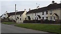
Houses at Love Lane, Cowbridge
If I am not mistaken these houses will be contemporary with, and perhaps part of, the Garden City developments of the early Twentieth Century.
Image: © Ruth Sharville
Taken: 21 Feb 2009
0.01 miles
2
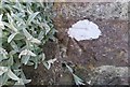
Ordnance Survey Cut Mark
This OS cut mark can be found on Porth Y Green. It marks a point 46.177m above mean sea level.
Image: © Adrian Dust
Taken: 19 Apr 2018
0.05 miles
4
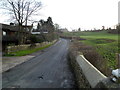
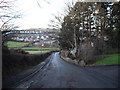
Constitution Hill Cowbridge
Constitution Hill climbs away from the corner of Mill Park. http://www.geograph.org.uk/photo/3625112
Image: © Jaggery
Taken: 19 Jan 2012
0.10 miles
5
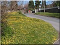
Carpet of celandines
Celandines on grass verge of main road between Llanblethian and Cowbridge. Note the wall-mounted red postbox
Image: © Ron Speed
Taken: 16 Aug 2007
0.11 miles
6
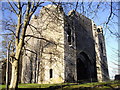
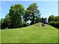
St Quentin's Castle, Llanblethian
Sometimes spelled St Quintin.
Image: © John Lord
Taken: 19 Jan 2011
0.13 miles
7
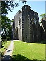
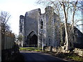
St. Quentin's Castle, Llanblethian
The remains of the gatehouse of St. Quentin's Castle or Llanblethian Castle. The castle was probably built in the early 14th century by Gilbert de Clare, a member of the powerful de Clare family.
Image: © Philip Halling
Taken: 14 Jun 2021
0.13 miles
8
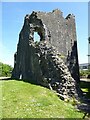
St. Quentin's Castle, Llanblethian
The remains of the gatehouse of St. Quentin's Castle or Llanblethian Castle. The castle was probably built in the early 14th century by Gilbert de Clare, a member of the powerful de Clare family.
Image: © Philip Halling
Taken: 14 Jun 2021
0.13 miles
9
St. Quentin's Castle or Llanblethian
The remains of St. Quentin's Castle or Llanblethian Castle. The castle was probably built in the early 14th century by Gilbert de Clare, a member of the powerful de Clare family.
Image: © Philip Halling
Taken: 14 Jun 2021
0.13 miles