IMAGES TAKEN NEAR TO
Dunraven Close, COWBRIDGE, CF71 7FG
Introduction
This page details the photographs taken nearby to Dunraven Close, CF71 7FG by members of the Geograph project.
The Geograph project started in 2005 with the aim of publishing, organising and preserving representative images for every square kilometre of Great Britain, Ireland and the Isle of Man.

There are currently over 7.5m images from over14,400 individuals and you can help contribute to the project by visiting https://www.geograph.org.uk
Image Map
Images are licensed for reuse under creativecommons.org/licenses/by-sa/2.0
Notes
- Clicking on the map will re-center to the selected point.
- The higher the marker number, the further away the image location is from the centre of the postcode.
Image Listing (23 Images Found)
Images are licensed for reuse under creativecommons.org/licenses/by-sa/2.0
Image
Details
Distance
1
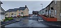
Car Ffynnon and Eastfield Close on the Clare Garden estate
Newly completed part of the estate, Cae Ffynnon will continue straight ahead into the construction site
Image: © Stephen Colebourne
Taken: 24 Dec 2019
0.07 miles
3
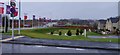
Cowbridge western bypass around Clare Garden estate
New bypass built as part of the large Clare Garden estate
Image: © Stephen Colebourne
Taken: 24 Dec 2019
0.09 miles
4
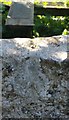
Ordnance Survey Rivet
This OS rivet can be found on the stile SE side of the road. It marks a point 63.249m above mean sea level.
Image: © Adrian Dust
Taken: 19 Apr 2018
0.12 miles
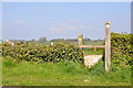
5
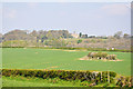
West of Cowbridge
A view across fields to an old barn and, in the distance, Penllyn Castle.
Image: © Mick Lobb
Taken: 20 Apr 2009
0.15 miles
6
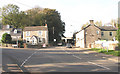
Cowbridge West End
At the west end of the town where the Llantwit Major road forks left off the old Roman Road
Image: © Tony Hodge
Taken: 3 Nov 2006
0.16 miles
7
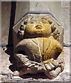
St John the Baptist, Llanblethian, Glamorgan, Wales - Porch corbel
Image: © John Salmon
Taken: 14 Aug 2007
0.16 miles
8
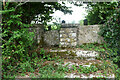
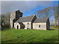
Stone Stile, Llanfrynach, Cowbridge
On Glamorgan footpath P3 32/2 which goes through the churchyard of St Brynach's Church.
More views of the church can be seen on http://www.geograph.org.uk/of/st+Brynach%27s+llanfrynach
Image: © Gerald Jarvis
Taken: 25 Sep 2024
0.18 miles
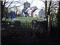
10
Church of St Brynach, Llanfrynach
The medieval parish church for Llanfrynach is dedicated to St Brynach. This isolated church which almost fell into disuse now has its rural setting ruined by the B4270 link road. That the church is not a ruin is down to Dr William Salmon of Penlline Court and the Homfray family. In 1776 three of the cracked and ruined bells were sold to pay for repairs to the church. The church is one of the very few to retain the stone benches gainst the walls which were used by the aged and infirmed, the rest of the parishioners standing for the whole of the services.
It is a Grade II listed building.
Image: © Colin Cheesman
Taken: 25 Jul 2021
0.20 miles