IMAGES TAKEN NEAR TO
Stradling Close, COWBRIDGE, CF71 7BX
Introduction
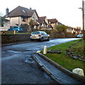
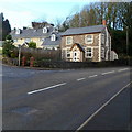
This page details the photographs taken nearby to Stradling Close, CF71 7BX by members of the Geograph project.
The Geograph project started in 2005 with the aim of publishing, organising and preserving representative images for every square kilometre of Great Britain, Ireland and the Isle of Man.

There are currently over 7.5m images from over14,400 individuals and you can help contribute to the project by visiting https://www.geograph.org.uk
Image Map
Images are licensed for reuse under creativecommons.org/licenses/by-sa/2.0
Notes
- Clicking on the map will re-center to the selected point.
- The higher the marker number, the further away the image location is from the centre of the postcode.
Image Listing (56 Images Found)
Images are licensed for reuse under creativecommons.org/licenses/by-sa/2.0
Image
Details
Distance
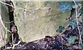
1
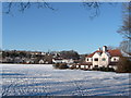
Looking north across snow-bound rugby field
Image: © Ron Speed
Taken: 7 Jan 2010
0.02 miles
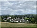
2
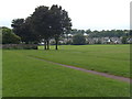
School playing fields Cowbridge
Western part of Cowbridge as seen across school rugby field.
Image: © Ron Speed
Taken: Unknown
0.06 miles
3
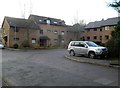
Hopyard Meadow, Cowbridge
Hopyard Meadow is a cul-de-sac on the south side of the A4222 Westgate.
Image: © Jaggery
Taken: 19 Jan 2012
0.07 miles
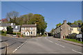
4
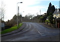
Llantwit Major Road, Cowbridge
The B4270 climbs away from the A4222.
The sign on the left points towards Llantwit Major and Llandow Industrial Estate.
Image: © Jaggery
Taken: 19 Jan 2012
0.07 miles
5
Ordnance Survey Cut Mark
This OS cut mark can be found on the wall SE side of Llantwit Major Road. It marks a point 46.735m above mean sea level.
Image: © Adrian Dust
Taken: 19 Apr 2018
0.07 miles
6
West Village, Cowbridge
Viewed from the slopes of Llanblethian Castle.
Image: © Alan Hughes
Taken: 15 Sep 2022
0.08 miles
7
West end of Cowbridge
The road to the left leads to Llandow and back to Llantwit Major and the road ahead to the A48, west to Bridgend and east to Cardiff.
Image: © Mick Lobb
Taken: 20 Apr 2009
0.08 miles
8
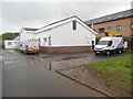
Cowbridge Telephone Exchange
Situated in Westgate, this TE has the code SWCNE. It provides telephone and broadband services to 3,076 residential and 315 non-residential premises in Cowbridge plus Aberthin, Graig Penllyn, llanblethian, Llysworney, Pentre Meyrick, St Hilary, St Mary Church, Sigingstone, Welsh St Donats and Ystradowen nearby. Two Openreach vehicles can be seen parked in front of this TE. The numbering range of this TE is (01446) 77xxxx, the (01446) referring to the Barry group of seven TEs, and its postcode is CF71 7AR.
Image: © David Hillas
Taken: 26 Apr 2019
0.08 miles
9
Tyla Rhosyr houses, Cowbridge
Tyla Rhosyr is a residential street on the north side of the B4270 Llantwit Major Road.
Image: © Jaggery
Taken: 27 Jan 2012
0.09 miles
10
Corner of Westgate and Llantwit Major Road, Cowbridge
The location is the NW edge of Cowbridge.
Image: © Jaggery
Taken: 19 Jan 2012
0.09 miles