IMAGES TAKEN NEAR TO
Woodland Close, COWBRIDGE, CF71 7AT
Introduction
This page details the photographs taken nearby to Woodland Close, CF71 7AT by members of the Geograph project.
The Geograph project started in 2005 with the aim of publishing, organising and preserving representative images for every square kilometre of Great Britain, Ireland and the Isle of Man.

There are currently over 7.5m images from over14,400 individuals and you can help contribute to the project by visiting https://www.geograph.org.uk
Image Map
Images are licensed for reuse under creativecommons.org/licenses/by-sa/2.0
Notes
- Clicking on the map will re-center to the selected point.
- The higher the marker number, the further away the image location is from the centre of the postcode.
Image Listing (74 Images Found)
Images are licensed for reuse under creativecommons.org/licenses/by-sa/2.0
Image
Details
Distance
1
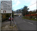
A4222 approaches a major junction in the NW of Cowbridge
Viewed along the A4222 Westgate, this is the approach to the A48 Cowbridge Bypass.
Image: © Jaggery
Taken: 19 Jan 2012
0.04 miles
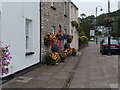
4
Old water pump in Westgate, Cowbridge
To the left of a litter bin is an old water pump, now part of a floral display.
How long ago did the pump last supply water to the residents of Cowbridge?
Image: © Jaggery
Taken: 19 Jan 2012
0.06 miles
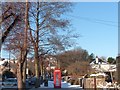
5
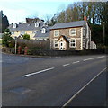
Corner of Westgate and Llantwit Major Road, Cowbridge
The location is the NW edge of Cowbridge.
Image: © Jaggery
Taken: 19 Jan 2012
0.07 miles
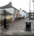
6
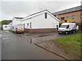
Cowbridge Telephone Exchange
Situated in Westgate, this TE has the code SWCNE. It provides telephone and broadband services to 3,076 residential and 315 non-residential premises in Cowbridge plus Aberthin, Graig Penllyn, llanblethian, Llysworney, Pentre Meyrick, St Hilary, St Mary Church, Sigingstone, Welsh St Donats and Ystradowen nearby. Two Openreach vehicles can be seen parked in front of this TE. The numbering range of this TE is (01446) 77xxxx, the (01446) referring to the Barry group of seven TEs, and its postcode is CF71 7AR.
Image: © David Hillas
Taken: 26 Apr 2019
0.07 miles
7
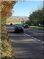
Road Junction
Slip road onto the A48, eastbound, at Cowbridge.
Image: © Alan Hughes
Taken: 7 Nov 2016
0.07 miles
8
Hopyard Meadow, Cowbridge
Hopyard Meadow is a cul-de-sac on the south side of the A4222 Westgate.
Image: © Jaggery
Taken: 19 Jan 2012
0.08 miles
9
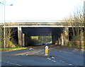
South side of the Cowbridge Bypass bridge over the A4222 in Cowbridge
The bridge carries the A48 Cowbridge Bypass over the A4222 at the northern edge of Cowbridge.
The town's northern boundary sign http://www.geograph.org.uk/photo/3638869 is on the far side of the bridge.
Image: © Jaggery
Taken: 19 Jan 2012
0.08 miles
10
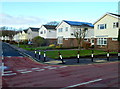
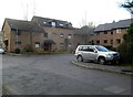
Modern houses in The Broad Shoard, Cowbridge
Located between Westgate and Cowbridge Athletic Club.
Image: © Jaggery
Taken: 19 Jan 2012
0.08 miles