IMAGES TAKEN NEAR TO
Fort Road, PENARTH, CF64 5UL
Introduction
This page details the photographs taken nearby to Fort Road, CF64 5UL by members of the Geograph project.
The Geograph project started in 2005 with the aim of publishing, organising and preserving representative images for every square kilometre of Great Britain, Ireland and the Isle of Man.

There are currently over 7.5m images from over14,400 individuals and you can help contribute to the project by visiting https://www.geograph.org.uk
Image Map
Images are licensed for reuse under creativecommons.org/licenses/by-sa/2.0
Notes
- Clicking on the map will re-center to the selected point.
- The higher the marker number, the further away the image location is from the centre of the postcode.
Image Listing (13 Images Found)
Images are licensed for reuse under creativecommons.org/licenses/by-sa/2.0
Image
Details
Distance
1
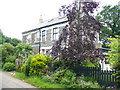
Fort Road
Traditional stone buildings on the narrow road from Cosmeston to Lavernock Point.
Image: © Colin Smith
Taken: 7 Jun 2008
0.12 miles
2
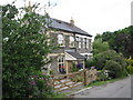
Ty-r-Orsaf cottages on Fort Road near Lavernock
Image: © Gareth James
Taken: 21 Jul 2010
0.13 miles
5
Beautifully carved bench by the Wales Coast Path
Near the Marconi Holiday Park. A memorial for Colin Vyvyan, a local volunteer at the nearby nature reserve.
Image: © Eirian Evans
Taken: 22 Jun 2021
0.18 miles
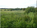
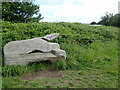
6
Former railway bridge near Lavernock
The line from Penarth to Cadoxton crossed Fort Road here.
Image: © Gareth James
Taken: 21 Jul 2010
0.19 miles
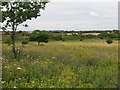
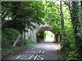
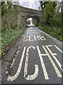
7
Fort Road Bridge
This bridge now carries the dismantled line of the coastal Barry-Penarth track. The road sign, of course, is bilingual.
Image: © Colin Smith
Taken: 7 Jun 2008
0.19 miles
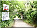
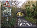
9
Bilingual warning sign
English and Welsh warnings on the road towards a low railway bridge.
Image: © Alan Hughes
Taken: 28 Jan 2020
0.20 miles
10
Arched Railway Bridge
The railway may be disused but this bridge still poses a hazard for high vehicles.
Image: © Alan Hughes
Taken: 17 Feb 2017
0.21 miles