IMAGES TAKEN NEAR TO
Swanbridge Grove, PENARTH, CF64 5TA
Introduction
This page details the photographs taken nearby to Swanbridge Grove, CF64 5TA by members of the Geograph project.
The Geograph project started in 2005 with the aim of publishing, organising and preserving representative images for every square kilometre of Great Britain, Ireland and the Isle of Man.

There are currently over 7.5m images from over14,400 individuals and you can help contribute to the project by visiting https://www.geograph.org.uk
Image Map
Images are licensed for reuse under creativecommons.org/licenses/by-sa/2.0
Notes
- Clicking on the map will re-center to the selected point.
- The higher the marker number, the further away the image location is from the centre of the postcode.
Image Listing (29 Images Found)
Images are licensed for reuse under creativecommons.org/licenses/by-sa/2.0
Image
Details
Distance
1
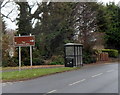
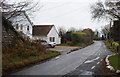
Sully : right turn ahead for the Captain's Wife
The sign alongside South Road points right towards this pub http://www.geograph.org.uk/photo/3268971
located about 500 metres away, in Swanbridge.
Image: © Jaggery
Taken: 2 Dec 2012
0.04 miles
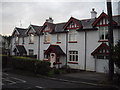
3

Swanbridge Road houses, Sully
The houses are on the west side of Swanbridge Road,
between South Road and a disused railway bridge. http://www.geograph.org.uk/photo/3264083
Image: © Jaggery
Taken: 2 Dec 2012
0.07 miles
4
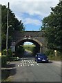
Railway Bridge
Disused railway bridge at Swanbridge Road, Sully.
Image: © Alan Hughes
Taken: 8 Aug 2016
0.07 miles
5
Bridge carrying dismantled railway over Swanbridge Rd, Sully
Looking north.
Image: © John Lord
Taken: 15 Jan 2012
0.07 miles
6
A view south from under the former railway bridge, Sully
Viewed from under this http://www.geograph.org.uk/photo/3264083 bridge looking along Swanbridge Road towards the B4267, the main road through Sully.
Image: © Jaggery
Taken: 2 Dec 2012
0.07 miles
7
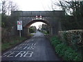
Bridge carrying dismantled railway over Swanbridge Rd, Sully
Looking south
Image: © John Lord
Taken: 15 Jan 2012
0.07 miles
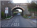
8
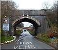
Swanbridge Road railway bridge, Sully
The railway formerly carried by the bridge has been dismantled, but the bridge itself remains as a potential hazard for high vehicles. The maximum overhead clearance is shown as 15' 3" or 4.6 metres, but of course that applies only in the middle of the road, to where drivers of high vehicles are directed by a sign and by road markings.
Image: © Jaggery
Taken: 2 Dec 2012
0.08 miles
9
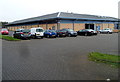
Main building in the Sully Sports and Social Club site
The building contains an indoor bowls arena, with catering facilities and a bar.
Image: © Jaggery
Taken: 2 Dec 2012
0.08 miles
10
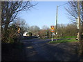
Junction of Beach Rd and Lavernock Rd, Sully
Image: © John Lord
Taken: 16 Jan 2012
0.08 miles