IMAGES TAKEN NEAR TO
Charteris Close, PENARTH, CF64 5RT
Introduction
This page details the photographs taken nearby to Charteris Close, CF64 5RT by members of the Geograph project.
The Geograph project started in 2005 with the aim of publishing, organising and preserving representative images for every square kilometre of Great Britain, Ireland and the Isle of Man.

There are currently over 7.5m images from over14,400 individuals and you can help contribute to the project by visiting https://www.geograph.org.uk
Image Map
Images are licensed for reuse under creativecommons.org/licenses/by-sa/2.0
Notes
- Clicking on the map will re-center to the selected point.
- The higher the marker number, the further away the image location is from the centre of the postcode.
Image Listing (39 Images Found)
Images are licensed for reuse under creativecommons.org/licenses/by-sa/2.0
Image
Details
Distance
1
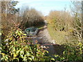
Site of former Lower Penarth Halt railway station
The view north from a bridge on Brockhill Rise. Ahead was the site of Lower Penarth Halt railway station, on the route from Penarth to Lavernock, Swanbridge Halt and Sully.
Cement works opened in Cosmeston in 1888. In the same year, the halt was opened principally for the use of workers at the adjacent quarries where limestone for the works was extracted. The halt closed in 1954.
Image: © Jaggery
Taken: 24 Nov 2010
0.04 miles
4
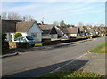
Caynham Avenue bungalows, Cosmeston
The west side of the avenue, viewed from the corner of Brockhill Rise.
Image: © Jaggery
Taken: 24 Nov 2010
0.07 miles
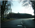
5

Entrance to Glamorganshire Golf Club, Cosmeston
The entrance is from Lavernock Road (B4267). The course occupies the eastern half of an area of land which has Cosmeston Lakes Country Park in its western half.
The club, which dates from 1890, is proud of its place in golf history. It was at the club in September 1898 that the Stableford scoring system was first tried by its creator, Dr Frank Stableford, at the time a member of The Glamorganshire.
Image: © Jaggery
Taken: 24 Nov 2010
0.07 miles
6
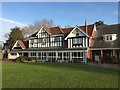
Glamorganshire Clubhouse
Clubhouse of Glamorganshire Golf Club.
Image: © Alan Hughes
Taken: 17 Feb 2017
0.08 miles
7
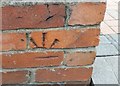
Ordnance Survey Cut Mark
This OS cut mark can be found on the wall of No210 Westbourne Road. It marks a point 17.297m above mean sea level.
Image: © Adrian Dust
Taken: 25 Sep 2017
0.08 miles
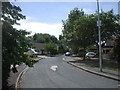
8
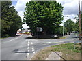
Junction of Lavernock Rd and Westbourne Rd, Penarth
Image: © John Lord
Taken: 6 Jul 2010
0.11 miles
9

Sunset over the Welsh coast
Viewed from Clevedon's Wain's Hill, the sun slips towards the Welsh coast around Barry and Penarth. The river is in serene mood this evening.
Image: © Neil Owen
Taken: 14 Aug 2022
0.11 miles
10
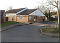
Lower Penarth Community Centre, Cosmeston
Located on Brockhill Way, near the corner of Brockhill Rise.
Various courses, such as Welsh for adults and Greek for beginners, are held here. The centre is also used by a wide variety of local clubs and groups, such as tai chi, Latin rhythms dance, yoga and taekwondo.
Image: © Jaggery
Taken: 24 Nov 2010
0.12 miles