IMAGES TAKEN NEAR TO
Kestrel Way, PENARTH, CF64 5FN
Introduction
This page details the photographs taken nearby to Kestrel Way, CF64 5FN by members of the Geograph project.
The Geograph project started in 2005 with the aim of publishing, organising and preserving representative images for every square kilometre of Great Britain, Ireland and the Isle of Man.

There are currently over 7.5m images from over14,400 individuals and you can help contribute to the project by visiting https://www.geograph.org.uk
Image Map
Images are licensed for reuse under creativecommons.org/licenses/by-sa/2.0
Notes
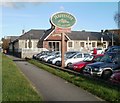
- Clicking on the map will re-center to the selected point.
- The higher the marker number, the further away the image location is from the centre of the postcode.
Image Listing (35 Images Found)
Images are licensed for reuse under creativecommons.org/licenses/by-sa/2.0
Image
Details
Distance
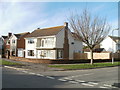
1
Halton Close, Cosmeston
Halton Close is a short cul-de-sac connecting with the corner of Stanton Way and Caynham Avenue.
Image: © Jaggery
Taken: 24 Nov 2010
0.04 miles
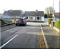
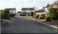
2
Corner of Stanton Way and Knowbury Avenue, Cosmeston
The houses on the left are on Stanton Way; the tree is on Knowbury Avenue.
Image: © Jaggery
Taken: 24 Nov 2010
0.08 miles
3
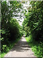
Cycle path near Penarth
On the route of the former Cadoxton to Penarth railway line.
Image: © Gareth James
Taken: 9 Jun 2010
0.08 miles
4
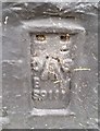
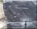
Ordnance Survey Flush Bracket (S9111)
This OS Flush Bracket can be found on the west face of The Schooner Inn. It marks a point 13.362m above mean sea level.
Image: © Adrian Dust
Taken: 25 Sep 2017
0.10 miles
5
Ordnance Survey Cut Mark
This OS cut mark can be found on the north angle of The Schooner Inn. It marks a point 13.728m above mean sea level.
Image: © Adrian Dust
Taken: 25 Sep 2017
0.10 miles
6
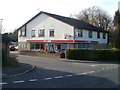
New post office in Spar, Brockhill Way, Cosmeston
When the nearby Stanwell Road post office closed in October 2009, the owners of this Spar store on Brockhill Way applied to Post Office Limited for authority to open an instore post office counter.
The new post office, named Lavernock Post Office Local, duly opened for business inside the store in February 2010.
Image: © Jaggery
Taken: 24 Nov 2010
0.12 miles
7
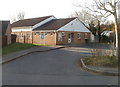
Lower Penarth Community Centre, Cosmeston
Located on Brockhill Way, near the corner of Brockhill Rise.
Various courses, such as Welsh for adults and Greek for beginners, are held here. The centre is also used by a wide variety of local clubs and groups, such as tai chi, Latin rhythms dance, yoga and taekwondo.
Image: © Jaggery
Taken: 24 Nov 2010
0.12 miles
8
Welcome to Lavernock
Lavernock Road, heading south, reaches the boundary sign for Lavernock, a hamlet between Penarth and Sully in the Vale of Glamorgan. The sign also shows Larnog, the Welsh name.
Image: © Jaggery
Taken: 24 Nov 2010
0.13 miles
9
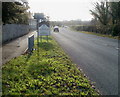
Schooner Inn, Lavernock
A Harvester pub and grill on the east side of Lavernock Road (B4267).
Image: © Jaggery
Taken: 24 Nov 2010
0.13 miles
10
Southern end of Whitcliffe Drive, Cosmeston
The main course of Whitcliffe Drive is north-south near the edge of cliffs facing the Bristol Channel (or Mouth of the Severn). There are three short west-facing arms near its southern end. This is the southernmost arm.
Image: © Jaggery
Taken: 24 Nov 2010
0.15 miles