IMAGES TAKEN NEAR TO
Westminster Drive, PENARTH, CF64 5ET
Introduction
This page details the photographs taken nearby to Westminster Drive, CF64 5ET by members of the Geograph project.
The Geograph project started in 2005 with the aim of publishing, organising and preserving representative images for every square kilometre of Great Britain, Ireland and the Isle of Man.

There are currently over 7.5m images from over14,400 individuals and you can help contribute to the project by visiting https://www.geograph.org.uk
Image Map
Images are licensed for reuse under creativecommons.org/licenses/by-sa/2.0
Notes
- Clicking on the map will re-center to the selected point.
- The higher the marker number, the further away the image location is from the centre of the postcode.
Image Listing (13 Images Found)
Images are licensed for reuse under creativecommons.org/licenses/by-sa/2.0
Image
Details
Distance
1
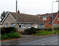
Sully Christian Fellowship
This bungalow is Croft Cottage, 27 South Road, where some activities of Sully Christian Fellowship take place. The main meeting place, where Sunday services are held, is the Jubilee Hall in Smithies Avenue.
Image: © Jaggery
Taken: 2 Dec 2012
0.16 miles
2
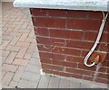
Ordnance Survey Cut Mark
This OS cut mark can be found on No67 Cog Road. It marks a point 43.327m above mean sea level.
Image: © Adrian Dust
Taken: 14 May 2024
0.16 miles
3
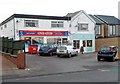
One Stop store, Sully
The nameboard of the One Stop at 55 South Road shows that the store is open every day from 6am to 11pm, including Sundays. The shop next door, with an inconspicuous name sign, is Cards & Candy, which opened in November 2012.
Image: © Jaggery
Taken: 2 Dec 2012
0.17 miles
4
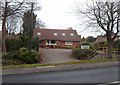
The Surgery, Sully
There is no name apart from Surgery in front of this building
at 25 South Road, set back 25 metres from the road.
Image: © Jaggery
Taken: 2 Dec 2012
0.17 miles
5
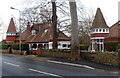
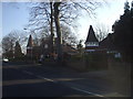
Unusual house towers, Sully
The houses are on the south side of South Road, near the corner of Minehead Avenue.
Image: © Jaggery
Taken: 2 Dec 2012
0.17 miles
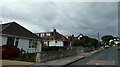
6
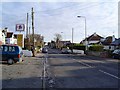
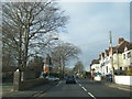
Sully High Street
The high street is the main Penarth to Barry Road. On either side of this road lie the residential streets of the ribbon development that comprises a large part of Sully.
Image: © Richard Knights
Taken: 24 Dec 2005
0.17 miles
8
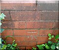
Ordnance Survey Cut Mark
This OS cut mark can be found on the wall of The Knoll. It marks a point 32.941m above mean sea level.
Image: © Adrian Dust
Taken: 14 May 2024
0.19 miles