IMAGES TAKEN NEAR TO
Barry Road, DINAS POWYS, CF64 4TR
Introduction
This page details the photographs taken nearby to Barry Road, CF64 4TR by members of the Geograph project.
The Geograph project started in 2005 with the aim of publishing, organising and preserving representative images for every square kilometre of Great Britain, Ireland and the Isle of Man.

There are currently over 7.5m images from over14,400 individuals and you can help contribute to the project by visiting https://www.geograph.org.uk
Image Map
Images are licensed for reuse under creativecommons.org/licenses/by-sa/2.0
Notes
- Clicking on the map will re-center to the selected point.
- The higher the marker number, the further away the image location is from the centre of the postcode.
Image Listing (3 Images Found)
Images are licensed for reuse under creativecommons.org/licenses/by-sa/2.0
Image
Details
Distance
1
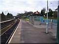
Dinas Powys railway station
Part of the valley rail link, this station serves the main Barry to Cardiff railway. It is well used.
Image: © Richard Knights
Taken: 26 Dec 2005
0.18 miles
2
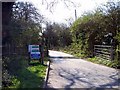
Cog Moors Treatment Works
The entrance to Cog Moors Treatment Works (the sewage works on the map) lies just within the boundaries of this square. It's not somewhere you particularly want to hang about, though, so I took the photo quickly and moved on.
Image: © Emrys Hopkins
Taken: 8 Apr 2007
0.19 miles
3
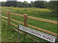
Buttercup Meadow
Buttercup meadow alongside Cross Common Road.
Image: © Alan Hughes
Taken: 31 May 2017
0.21 miles