IMAGES TAKEN NEAR TO
Laburnum Way, DINAS POWYS, CF64 4TH
Introduction
This page details the photographs taken nearby to Laburnum Way, CF64 4TH by members of the Geograph project.
The Geograph project started in 2005 with the aim of publishing, organising and preserving representative images for every square kilometre of Great Britain, Ireland and the Isle of Man.

There are currently over 7.5m images from over14,400 individuals and you can help contribute to the project by visiting https://www.geograph.org.uk
Image Map
Images are licensed for reuse under creativecommons.org/licenses/by-sa/2.0
Notes
- Clicking on the map will re-center to the selected point.
- The higher the marker number, the further away the image location is from the centre of the postcode.
Image Listing (13 Images Found)
Images are licensed for reuse under creativecommons.org/licenses/by-sa/2.0
Image
Details
Distance
1
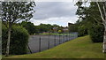
Tennis courts at Hebron Hall
Some of the sport facilities at Hebron Hall Christian centre in Dinas Powys.
Image: © Peter Mackenzie
Taken: 28 May 2019
0.14 miles
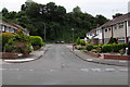
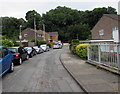
2
St Teilo Close, Dinas Powys
Cul-de-sac on the south side of St Cadoc's Avenue.
Image: © Jaggery
Taken: 11 Aug 2016
0.19 miles
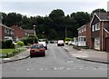
3
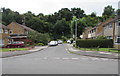
Eastern end of St Cadoc's Avenue, Dinas Powys
St Cadoc's Avenue ends a few metres beyond the St Teilo Close junction on the right.
East Brook flows below the bank on the left.
Image: © Jaggery
Taken: 11 Aug 2016
0.21 miles
4
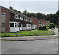
East side of St Dyfrig's Close, Dinas Powys
Houses in a cul-de-sac on the southeast side of St Cadoc's Avenue.
Image: © Jaggery
Taken: 11 Aug 2016
0.21 miles
5
St Illtyd Close, Dinas Powys
Cul-de-sac on the south side of St Cadoc's Avenue.
Image: © Jaggery
Taken: 11 Aug 2016
0.21 miles
6
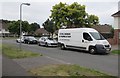
Steel Design & Fabrication van, Pen-y-Waun, Dinas Powys
The text on the van door is Fabricators for Doctor Who - Torchwood - DaVinci's Demons.
Image: © Jaggery
Taken: 11 Aug 2016
0.22 miles
7
St Dyfrig's Close, Dinas Powys
Cul-de-sac on the southeast side of St Cadoc's Avenue.
Image: © Jaggery
Taken: 11 Aug 2016
0.22 miles
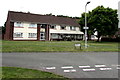
8
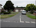
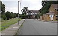
Pen-y-Waun, Dinas Powys
Road from Plas Essyllt to Fairoaks.
Image: © Jaggery
Taken: 11 Aug 2016
0.23 miles
9
St Lythan Close, Dinas Powys
Cul-de-sac on the southeast side of St Cadoc's Avenue. The railings are above East Brook. http://www.geograph.org.uk/photo/5109328
Image: © Jaggery
Taken: 11 Aug 2016
0.24 miles
10
Youldon House, Fairoaks, Dinas Powys
Sheltered housing on the west side of Fairoaks. The sign on the lamppost points towards Bethesda Chapel. http://www.geograph.org.uk/photo/5071825
Image: © Jaggery
Taken: 11 Aug 2016
0.24 miles