IMAGES TAKEN NEAR TO
Murch Road, DINAS POWYS, CF64 4RE
Introduction
This page details the photographs taken nearby to Murch Road, CF64 4RE by members of the Geograph project.
The Geograph project started in 2005 with the aim of publishing, organising and preserving representative images for every square kilometre of Great Britain, Ireland and the Isle of Man.

There are currently over 7.5m images from over14,400 individuals and you can help contribute to the project by visiting https://www.geograph.org.uk
Image Map
Images are licensed for reuse under creativecommons.org/licenses/by-sa/2.0
Notes
- Clicking on the map will re-center to the selected point.
- The higher the marker number, the further away the image location is from the centre of the postcode.
Image Listing (19 Images Found)
Images are licensed for reuse under creativecommons.org/licenses/by-sa/2.0
Image
Details
Distance
1
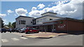
Murch medical practice
The medical practice and pharmacy at Murch.
Image: © Peter Mackenzie
Taken: 28 May 2019
0.05 miles
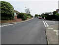
2
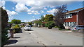
House in Murch
A residential street on the outskirts of Murch.
Image: © Peter Mackenzie
Taken: 28 May 2019
0.06 miles
3
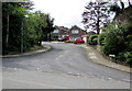
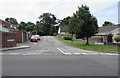
Windyridge, Dinas Powys
The northern edge of a long cul-de-sac viewed across Murch Road. The red car is on the corner of The Drive.
Image: © Jaggery
Taken: 5 Aug 2016
0.11 miles
4
Llandilo Close, Dinas Powys
Cul-de-sac on the south side of Raglan Close. Llandilo used to be a variant spelling of Llandeilo.
Image: © Jaggery
Taken: 5 Aug 2016
0.11 miles
5
Madoc Close, Dinas Powys
Cul-de-sac on the south side of Raglan Close.
Image: © Jaggery
Taken: 5 Aug 2016
0.12 miles
6

Sealed postbox in a Murch Road wall, Dinas Powys
Located here. http://www.geograph.org.uk/photo/5063007 In August 2016, the words OUT SERVICE are on the piece of wood sealing the aperture.
Image: © Jaggery
Taken: 5 Aug 2016
0.13 miles
7
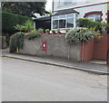
You can't post a letter here, Murch Road, Dinas Powys
In early August 2016, the aperture of the wall postbox is sealed. http://www.geograph.org.uk/photo/5063005
Image: © Jaggery
Taken: 5 Aug 2016
0.13 miles
8
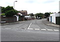
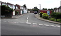
Cardigan Road, Dinas Powys
Connecting Cardigan Close on this side with Raglan Close out of shot 75 metres from the camera.
Image: © Jaggery
Taken: 5 Aug 2016
0.14 miles
9
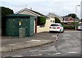
Electricity substation on a Dinas Powys corner
The large dark green cabinet on the corner of Cardigan Road and Raglan Close
is a Western Power Distribution electricity substation. Its identifier is S/S 512882.
Image: © Jaggery
Taken: 5 Aug 2016
0.15 miles
10
East along Raglan Close, Dinas Powys
The Cardigan Road junction is on the left. The Llandilo Close junction http://www.geograph.org.uk/photo/5083279 is on the right.
Image: © Jaggery
Taken: 5 Aug 2016
0.17 miles