IMAGES TAKEN NEAR TO
Michaelston-le-Pit, DINAS POWYS, CF64 4HP
Introduction
This page details the photographs taken nearby to CF64 4HP by members of the Geograph project.
The Geograph project started in 2005 with the aim of publishing, organising and preserving representative images for every square kilometre of Great Britain, Ireland and the Isle of Man.

There are currently over 7.5m images from over14,400 individuals and you can help contribute to the project by visiting https://www.geograph.org.uk
Image Map
Images are licensed for reuse under creativecommons.org/licenses/by-sa/2.0
Notes
- Clicking on the map will re-center to the selected point.
- The higher the marker number, the further away the image location is from the centre of the postcode.
Image Listing (36 Images Found)
Images are licensed for reuse under creativecommons.org/licenses/by-sa/2.0
Image
Details
Distance
1
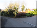
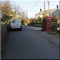
Cwrt-yr-Ala Road, Michaelston-le-Pit
Past the entrance drive to The Courtyard, http://www.geograph.org.uk/photo/5206365 this road leads to Caerau at the edge of Cardiff.
Image: © Jaggery
Taken: 25 Nov 2016
0.02 miles
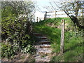
3
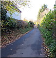
Steps up from Cwrt-yr-Ala Road, Michaelston-le-Pit
Ascending to a public footpath through a field.
Image: © Jaggery
Taken: 25 Nov 2016
0.03 miles
4
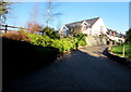
The Courtyard, Michaelston-le-Pit
House set above Cwrt-yr-Ala Road.
Image: © Jaggery
Taken: 25 Nov 2016
0.03 miles
5
Village noticeboard, St Michael's Close, Michaelston-le-Pit
Among the notices on display in late November 2016 are the Penarth & District Ramblers' November 2016 programme, an advert for CP Paws dog walking and pet sitting service and details of a public meeting in the Parish Hall, Britway Road.
Image: © Jaggery
Taken: 25 Nov 2016
0.05 miles
6

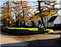
Michaelston-le-Pit houses
On the northeast side of Cwrt-yr-Ala Road.
Image: © Jaggery
Taken: 25 Nov 2016
0.05 miles
7
Michaelston-le-Pit cottages
On the northeast side of houses in St Michael's Close.
Image: © Jaggery
Taken: 25 Nov 2016
0.06 miles
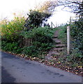
8
West along Cwrt-yr-Ala Road, Michaelston-le-Pit
Viewed from the edge of these steps http://www.geograph.org.uk/photo/5206404 looking away from the centre of the village.
Image: © Jaggery
Taken: 25 Nov 2016
0.06 miles
9

Inside the village phonebox, Michaelston-le-Pit
Located here. http://www.geograph.org.uk/photo/5206243 Though I didn't try to make a phone call, I lifted the handset and heard a dial tone.
Image: © Jaggery
Taken: 25 Nov 2016
0.06 miles
10
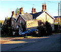
Village phonebox and bookstore, Michaelston-le-Pit
Grade II listed in 1990, this is a K6 type red kiosk of a standard design introduced by the GPO in 1936.
In late November 2016 a working telephone and many books are inside the box. http://www.geograph.org.uk/photo/5206248
Image: © Jaggery
Taken: 25 Nov 2016
0.06 miles