IMAGES TAKEN NEAR TO
Pen-y-Turnpike Road, DINAS POWYS, CF64 4HG
Introduction
This page details the photographs taken nearby to Pen-y-Turnpike Road, CF64 4HG by members of the Geograph project.
The Geograph project started in 2005 with the aim of publishing, organising and preserving representative images for every square kilometre of Great Britain, Ireland and the Isle of Man.

There are currently over 7.5m images from over14,400 individuals and you can help contribute to the project by visiting https://www.geograph.org.uk
Image Map
Images are licensed for reuse under creativecommons.org/licenses/by-sa/2.0
Notes
- Clicking on the map will re-center to the selected point.
- The higher the marker number, the further away the image location is from the centre of the postcode.
Image Listing (14 Images Found)
Images are licensed for reuse under creativecommons.org/licenses/by-sa/2.0
Image
Details
Distance
1
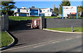
Recently built house near Dinas Powys
Set back from Penyturnpike Road near the northern edge of Dinas Powys,
viewed in November 2016. The name on the board is Mark Chapman Construction.
Image: © Jaggery
Taken: 25 Nov 2016
0.09 miles
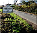
2
Bend in Penyturnpike Road, Dinas Powys
The grey back of the Dinas Powys boundary sign http://www.geograph.org.uk/photo/5205638 is on the right.
Image: © Jaggery
Taken: 25 Nov 2016
0.11 miles
3
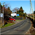
Combined speed limit and speed camera sign, Penyturnpike Road near Dinas Powys
Facing northbound traffic on the minor road from Dinas Powys to Michaelston-le-Pit.
Image: © Jaggery
Taken: 25 Nov 2016
0.12 miles
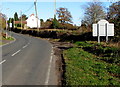
4
Welcome to Dinas Powys - Please drive carefully
The Welcome sign is alongside Penyturnpike Road at the northern edge of Dinas Powys, a large village in the Vale of Glamorgan. The population of Dinas Powys on the day of the 2011 UK Census was 7,490. The Welcome (Croeso) is also in Welsh.
Image: © Jaggery
Taken: 25 Nov 2016
0.13 miles
5
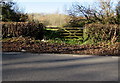
Wooden gate at the edge of woodland north of Dinas Powys
The word WOODLAND is inscribed on the wooden gate between Penyturnpike Road and the wood named Coedwaunwyllt.
Image: © Jaggery
Taken: 25 Nov 2016
0.13 miles
6
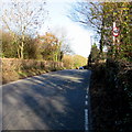
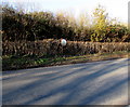
Inconspicuous speed limit sign, Penyturnpike Road north of Dinas Powys
The small 40 sign is partly hidden by vegetation.
Image: © Jaggery
Taken: 25 Nov 2016
0.13 miles
7
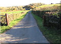
Mill Farm access road, Dinas Powys
From Penyturnpike Road.
Image: © Jaggery
Taken: 25 Nov 2016
0.16 miles
8
Public footpath past Holm View north of Dinas Powys
Behind the camera, a public footpath sign on the corner of Penyturnpike Road points this way. Holm View is on the left.
Image: © Jaggery
Taken: 25 Nov 2016
0.18 miles
9
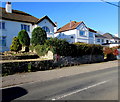
White houses and a red postbox, Penyturnpike Road, Dinas Powys
Near the northern edge of Dinas Powys. The postbox is Edwardian. http://www.geograph.org.uk/photo/5205644
Image: © Jaggery
Taken: 25 Nov 2016
0.19 miles
10
Visibility mirror alongside Penyturnpike Road north of Dinas Powys
Opposite Holm View and this http://www.geograph.org.uk/photo/5348004 public footpath.
Image: © Jaggery
Taken: 25 Nov 2016
0.19 miles