IMAGES TAKEN NEAR TO
The Common, DINAS POWYS, CF64 4DU
Introduction
This page details the photographs taken nearby to The Common, CF64 4DU by members of the Geograph project.
The Geograph project started in 2005 with the aim of publishing, organising and preserving representative images for every square kilometre of Great Britain, Ireland and the Isle of Man.

There are currently over 7.5m images from over14,400 individuals and you can help contribute to the project by visiting https://www.geograph.org.uk
Image Map
Images are licensed for reuse under creativecommons.org/licenses/by-sa/2.0
Notes
- Clicking on the map will re-center to the selected point.
- The higher the marker number, the further away the image location is from the centre of the postcode.
Image Listing (32 Images Found)
Images are licensed for reuse under creativecommons.org/licenses/by-sa/2.0
Image
Details
Distance
1
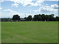
Dinas Powys Common
Cricket being played on the Common, looking south towards Barry, the Bristol Channel and England
Image: © Simon Hiscocks
Taken: 29 Jul 2007
0.09 miles
2
Boulders at the edge of Mount Road, Dinas Powys
The boulders prevent motor vehicles driving on Dinas Powys Common.
Image: © Jaggery
Taken: 13 Aug 2016
0.11 miles
3
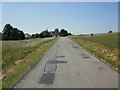
Southra, Dinas Powys Common
Southra runs from Station Road through Dinas Powys Common. This view is looking southwestwards from near the Station Road end.
Image: © Jaggery
Taken: 16 Jun 2010
0.11 miles
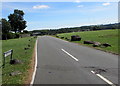
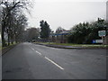
4
From 20 to 30, Mount Road, Dinas Powys
The 20mph speed limit on St Andrew's Road near a school
increases to 30mph on Mount Road through Dinas Powys Common.
Image: © Jaggery
Taken: 13 Aug 2016
0.12 miles
6
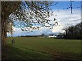
Dinas Powis Common
The common, Westra, Dinas Powis.
Image: © Alan Hughes
Taken: 4 Apr 2016
0.13 miles
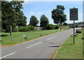
7
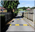
Entrance road to Dinas Powys Tennis Club
From St Andrew's Road past the edge of Dinas Powys Bowling Club on the left.
Speed bumps are near signs showing a 10mph speed limit.
Image: © Jaggery
Taken: 13 Aug 2016
0.15 miles
8
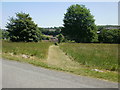
Mown grassy track, Dinas Powys Common
A track covered with short grass heads through long grass from Southra http://www.geograph.org.uk/photo/1918850 towards Station Road.
Image: © Jaggery
Taken: 16 Jun 2010
0.16 miles
9
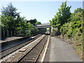
Barry Road railway bridge, Dinas Powys
Viewed from Dinas Powys station. The bridge carries the A4055, here named Barry Road.
Image: © Jaggery
Taken: 16 Jun 2010
0.17 miles
10
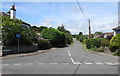
Twyncyn, Dinas Powys
This junction at the southern end of Twyncyn is where St Andrew's Road on the left becomes Britway Road on the right.
Image: © Jaggery
Taken: 13 Aug 2016
0.19 miles