1
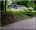
Lettons Way, Dinas Powys
Dead-end road viewed from the corner of Mill Road. The road on the left leads to St Peter's Church. http://www.geograph.org.uk/photo/5080716
Image: © Jaggery
Taken: 18 Aug 2016
0.05 miles
2
Ordnance Survey Cut Mark
This OS cut mark can be found on the NW face of St Peter's Church. It marks a point 16.444m above mean sea level.
Image: © Adrian Dust
Taken: 16 Mar 2018
0.09 miles
3
St Peter's church - Dinas Powys
Image: © Mick Lobb
Taken: 13 Sep 2009
0.09 miles
4
Highwalls Road, Dinas Powys
Looking to the northwest from the Highwalls Avenue junction.
Image: © Jaggery
Taken: 13 Aug 2016
0.09 miles
5
Cadoxton River near Dinas Powys
Image: © John Light
Taken: 19 Jan 2013
0.10 miles
6
Grade II listed St Peter's Church, Dinas Powys
Viewed across Lettons Way. St Peter's Church is part of the Parish of St Andrew Major in the Church in Wales Diocese of Llandaff. The church was built in the 1930s to serve the growing community of Dinas Powys whose earlier parish church is in the nearby hamlet of St Andrew's Major. The building was Grade II listed in 2002.
Image: © Jaggery
Taken: 18 Aug 2016
0.10 miles
7
St Peter's Church, Dinas Powys
St Peter's Church is part of the Parish of St Andrew Major in the Church in Wales Diocese of Llandaff.
The church was built in the 1930s to serve the growing community of Dinas Powys whose earlier parish church is in the nearby hamlet of St Andrew's Major. The building was Grade II listed in 2002.
Image: © Jaggery
Taken: 18 Aug 2016
0.10 miles
8
St Peter's Church Hall, Dinas Powys
Set back 15 metres from the south side of St Peter's Church. http://www.geograph.org.uk/photo/5080745
Image: © Jaggery
Taken: 18 Aug 2016
0.10 miles
9
Grade II listed St Peter's Church, Dinas Powys
Viewed from the corner of Lettons Way. http://www.geograph.org.uk/photo/5080731 St Peter's Church is part of the Parish of St Andrew Major in the Church in Wales Diocese of Llandaff. The church was built in the 1930s to serve the growing community of Dinas Powys whose earlier parish church is in the nearby hamlet of St Andrew's Major.
The building was Grade II listed in 2002.
Image: © Jaggery
Taken: 18 Aug 2016
0.10 miles
10
Dinas Powys telephone exchange
BT premises set back from the west side of Mill Road near the corner of Lettons Way.
The exchange identifier is SWDPW.
Image: © Jaggery
Taken: 18 Aug 2016
0.11 miles


