IMAGES TAKEN NEAR TO
Greenfield Avenue, DINAS POWYS, CF64 4BW
Introduction
This page details the photographs taken nearby to Greenfield Avenue, CF64 4BW by members of the Geograph project.
The Geograph project started in 2005 with the aim of publishing, organising and preserving representative images for every square kilometre of Great Britain, Ireland and the Isle of Man.

There are currently over 7.5m images from over14,400 individuals and you can help contribute to the project by visiting https://www.geograph.org.uk
Image Map
Images are licensed for reuse under creativecommons.org/licenses/by-sa/2.0
Notes
- Clicking on the map will re-center to the selected point.
- The higher the marker number, the further away the image location is from the centre of the postcode.
Image Listing (140 Images Found)
Images are licensed for reuse under creativecommons.org/licenses/by-sa/2.0
Image
Details
Distance
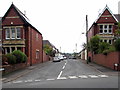
1
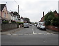
Greenfield Avenue, Dinas Powys
Viewed across Penyturnpike Road. Greenfield Avenue extends for 300 metres to the A4055 Cardiff Road.
Image: © Jaggery
Taken: 18 Aug 2016
0.02 miles
2
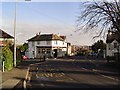
Downtown Dinas Powys
A view of the central square of Dinas Powys taken from the bus stop. The building straight ahead is the Natwest bank and on the right is the Three Horseshoes pub.
Image: © Richard Knights
Taken: 24 Dec 2005
0.03 miles
3
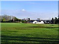
Dinas Powys golf club
A view of the clubhouse. This golf course is pretty well ensconsed within the village. Not far to walk for urban golfers!
Image: © Richard Knights
Taken: 24 Dec 2005
0.03 miles
4
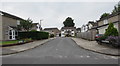
Millbrook Close, Dinas Powys
Cul-de-sac on the south side of Millbrook Road.
Image: © Jaggery
Taken: 18 Aug 2016
0.04 miles
5
Northwest end of Stacey Road, Dinas Powys
Viewed across Mill Road. Stacey Road extends southeastwards for 200 metres to Edith Road.
Image: © Jaggery
Taken: 18 Aug 2016
0.04 miles
6
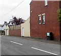
Telecoms cabinet, Stacey Road, Dinas Powys
Viewed in August 2016. There was no cabinet here in a July 2012 Google Earth Street View.
Image: © Jaggery
Taken: 18 Aug 2016
0.05 miles
7
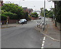
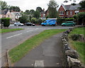
Mill Road traffic calming, Dinas Powys
Viewed from the corner of Lettons Way.
Mill Road narrows to one lane for a few metres.
Traffic on this side has priority through the narrowing.
Image: © Jaggery
Taken: 18 Aug 2016
0.06 miles
9
Downstream along the Cadoxton River, Dinas Powys
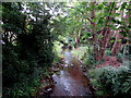
Looking to the southeast from this http://www.geograph.org.uk/photo/5080955 bridge. http://www.geograph.org.uk/photo/5080972 to an upstream view.
About 8km long, the streamlike Cadoxton River is one of the shortest rivers (so named) in Wales.
Image: © Jaggery
Taken: 18 Aug 2016
0.06 miles
10
Junction of Lettons Way and Mill Road, Dinas Powys
The low stone wall at the edge of Lettons Way is the perimeter wall of the St Peter's Church site. http://www.geograph.org.uk/photo/5080745
Image: © Jaggery
Taken: 18 Aug 2016
0.06 miles