1
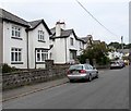
White houses, Stacey Road, Dinas Powys
Image: © Jaggery
Taken: 18 Aug 2016
0.01 miles
2
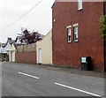
Mill Close, Dinas Powys
Houses on the north side of Mill Close, viewed across Mill Road.
Image: © Jaggery
Taken: 25 Nov 2016
0.02 miles
3
Northwest end of Stacey Road, Dinas Powys
Viewed across Mill Road. Stacey Road extends southeastwards for 200 metres to Edith Road.
Image: © Jaggery
Taken: 18 Aug 2016
0.03 miles
4
Telecoms cabinet, Stacey Road, Dinas Powys
Viewed in August 2016. There was no cabinet here in a July 2012 Google Earth Street View.
Image: © Jaggery
Taken: 18 Aug 2016
0.04 miles
5
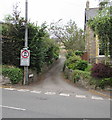
Heol-y-cawl, Dinas Powys
The eastern end of Heol-y-cawl, viewed across Mill Road.
No motor vehicles ahead, except for access.
Image: © Jaggery
Taken: 18 Aug 2016
0.04 miles
6
Millbank House, Dinas Powys
On the west side of Mill Road, near the Mill Close junction.
Image: © Jaggery
Taken: 25 Nov 2016
0.04 miles
7
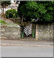
Ornate gate, Mill Road, Dinas Powys
The distinctive gate is at the entrance to a Mill Road house near this http://www.geograph.org.uk/photo/5079366 corner of Heol-y-cawl.
Image: © Jaggery
Taken: 18 Aug 2016
0.04 miles
8
Mill Road, Dinas Powys
The southern end of Mill Road, viewed from The Square.
Happy Embroidery on the left is at 6 The Square.
A former NatWest bank branch http://www.geograph.org.uk/photo/5070274 is on the right.
Image: © Jaggery
Taken: 11 Aug 2016
0.05 miles
9
Stacey Road, Dinas Powys
Viewed across Edith Road. Stacey Road extends for 200 metres to Mill Road.
Image: © Jaggery
Taken: 18 Aug 2016
0.05 miles
10
NatWest bank, Dinas Powys
The bank on the corner of Elm Grove Road and Mill Road is open for business in late November 2016. NatWest had planned to close down this branch in August 2016, but it remains open while the nearest Natwest branch (in Penarth) is temporarily closed.
Image: © Jaggery
Taken: 25 Nov 2016
0.05 miles


