IMAGES TAKEN NEAR TO
Cae Canol, PENARTH, CF64 3RF
Introduction
This page details the photographs taken nearby to Cae Canol, CF64 3RF by members of the Geograph project.
The Geograph project started in 2005 with the aim of publishing, organising and preserving representative images for every square kilometre of Great Britain, Ireland and the Isle of Man.

There are currently over 7.5m images from over14,400 individuals and you can help contribute to the project by visiting https://www.geograph.org.uk
Image Map
Images are licensed for reuse under creativecommons.org/licenses/by-sa/2.0
Notes
- Clicking on the map will re-center to the selected point.
- The higher the marker number, the further away the image location is from the centre of the postcode.
Image Listing (50 Images Found)
Images are licensed for reuse under creativecommons.org/licenses/by-sa/2.0
Image
Details
Distance
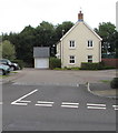
1
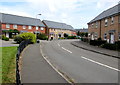
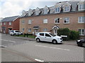
Houses near a bend in Cae Canol, Lower Penarth
Image: © Jaggery
Taken: 5 Aug 2016
0.02 miles
2
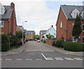
Side arm of Heol Tre Forys, Lower Penarth
On the NW side of the main course of Heol Tre Forys.
Image: © Jaggery
Taken: 5 Aug 2016
0.03 miles
3
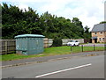
Haversham Park electricity substation, Cae Canol, Lower Penarth
The green cabinet is a Western Power Distribution electricity substation.
Its identifier is HAVERSHAM PARK S/S 513332.
Image: © Jaggery
Taken: 5 Aug 2016
0.04 miles
4
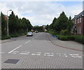
Heol Tre Forys, Lower Penarth
Viewed from the three-way junction where Heol Tre Forys
is ahead, Cae Canol to the left and Tair Gwaun to the right.
Image: © Jaggery
Taken: 5 Aug 2016
0.04 miles
5
Tair Gwaun houses, Lower Penarth
Viewed from the corner of Heol Tre Forys and Cae Canol.
Image: © Jaggery
Taken: 5 Aug 2016
0.06 miles
6
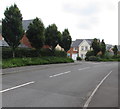
Tree-lined Heol Tre Forys, Lower Penarth
Viewed from near the roundabout at the western end of Dinas Road.
Image: © Jaggery
Taken: 5 Aug 2016
0.06 miles
7
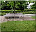
Metal bench around a tree, Lower Penarth
On the pavement on the west side of this http://www.geograph.org.uk/photo/5062635 roundabout.
Image: © Jaggery
Taken: 5 Aug 2016
0.07 miles
8
Cogan Hall. Penarth
New suburban development at the western end of Dinas Road in Penarth.
Image: © Colin Smith
Taken: 7 Jun 2008
0.07 miles
9
House and garage, Heol Tre Forys, Lower Penarth
Set back from the east side of the main course of Heol Tre Forys.
Image: © Jaggery
Taken: 5 Aug 2016
0.07 miles
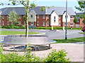
10
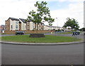
Young tree on a Lower Penarth roundabout
On the roundabout at the junction of Dinas Road, Heol y Brenin and Heol Tre Forys, viewed on August 5th 2016. This young tree is an excellent subject for a time lapse study.
Any local volunteers for a similar view in August 2017, August 2018, August 2019... ?
Image: © Jaggery
Taken: 5 Aug 2016
0.07 miles