IMAGES TAKEN NEAR TO
Lavernock Road, PENARTH, CF64 3QF
Introduction
This page details the photographs taken nearby to Lavernock Road, CF64 3QF by members of the Geograph project.
The Geograph project started in 2005 with the aim of publishing, organising and preserving representative images for every square kilometre of Great Britain, Ireland and the Isle of Man.

There are currently over 7.5m images from over14,400 individuals and you can help contribute to the project by visiting https://www.geograph.org.uk
Image Map
Images are licensed for reuse under creativecommons.org/licenses/by-sa/2.0
Notes
- Clicking on the map will re-center to the selected point.
- The higher the marker number, the further away the image location is from the centre of the postcode.
Image Listing (9 Images Found)
Images are licensed for reuse under creativecommons.org/licenses/by-sa/2.0
Image
Details
Distance

2
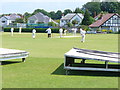
Cricket at Penarth
Penarth Athletics Field caters for cricket, lacrosse and rugby. A range of sports pavilions faces the playing areas.
http://www.penarthcricket.co.uk/
Image: © Colin Smith
Taken: 7 Jun 2008
0.10 miles
3
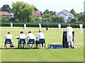
Penarth Athletics Field
A well-used sports ground in Lower Penarth caters for cricket, rugby and lacrosse.
http://www.penarthcricket.co.uk/
Image: © Colin Smith
Taken: 7 Jun 2008
0.13 miles
7
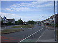
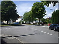
B4267 Lavernock Road south of crossroads, Penarth
The Victoria Road junction is on the left, Dinas Road on the right
Image: © Jaggery
Taken: 28 Jul 2016
0.23 miles
8
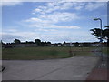
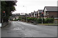
Junction of Forrest Rd and Lavernock Rd, Penarth
Image: © John Lord
Taken: 6 Jul 2010
0.24 miles