IMAGES TAKEN NEAR TO
Owain Close, PENARTH, CF64 3LU
Introduction
This page details the photographs taken nearby to Owain Close, CF64 3LU by members of the Geograph project.
The Geograph project started in 2005 with the aim of publishing, organising and preserving representative images for every square kilometre of Great Britain, Ireland and the Isle of Man.

There are currently over 7.5m images from over14,400 individuals and you can help contribute to the project by visiting https://www.geograph.org.uk
Image Map
Images are licensed for reuse under creativecommons.org/licenses/by-sa/2.0
Notes
- Clicking on the map will re-center to the selected point.
- The higher the marker number, the further away the image location is from the centre of the postcode.
Image Listing (10 Images Found)
Images are licensed for reuse under creativecommons.org/licenses/by-sa/2.0
Image
Details
Distance
2
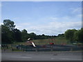
Children's playground, Owain Close, Penarth
Image: © John Lord
Taken: 6 Jul 2010
0.08 miles
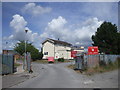
4
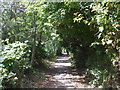
Footpath beside Ysgol Erw'r Delyn, Penarth
For those who don't know Welsh, Ysgol Erw'r Delyn is a Welsh-medium school.
Image: © John Lord
Taken: 6 Jul 2010
0.16 miles
5
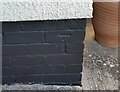
Ordnance Survey Cut Mark
This OS cut mark can be found on No57 Mountjoy Avenue. It marks a point 37.763m above mean sea level.
Image: © Adrian Dust
Taken: 17 Sep 2021
0.16 miles
6
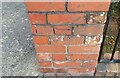
Ordnance Survey Cut Mark
This OS cut mark can be found on the wall of No77 Redlands Road. It marks a point 33.484m above mean sea level.
Image: © Adrian Dust
Taken: 17 Sep 2021
0.18 miles
8

Erroneous name sign, Laburnum Way, Penarth
Most references show Laburnum Way whereas the name sign on the left shows LABURNAM WAY.
Image: © Jaggery
Taken: 28 Jul 2016
0.23 miles
9

Junction of Laburnum Way and Hazel Road, Penarth
Hazel Road from the left joins Laburnum Way.
Image: © Jaggery
Taken: 28 Jul 2016
0.24 miles
10
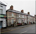
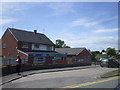
Row of houses, Redlands Road, Penarth
Extending for 30 metres from the north side of the Cefn Mably Hotel. http://www.geograph.org.uk/photo/5054468
Image: © Jaggery
Taken: 28 Jul 2016
0.24 miles