IMAGES TAKEN NEAR TO
Victoria Road, PENARTH, CF64 3EG
Introduction
This page details the photographs taken nearby to Victoria Road, CF64 3EG by members of the Geograph project.
The Geograph project started in 2005 with the aim of publishing, organising and preserving representative images for every square kilometre of Great Britain, Ireland and the Isle of Man.

There are currently over 7.5m images from over14,400 individuals and you can help contribute to the project by visiting https://www.geograph.org.uk
Image Map
Images are licensed for reuse under creativecommons.org/licenses/by-sa/2.0
Notes
- Clicking on the map will re-center to the selected point.
- The higher the marker number, the further away the image location is from the centre of the postcode.
Image Listing (230 Images Found)
Images are licensed for reuse under creativecommons.org/licenses/by-sa/2.0
Image
Details
Distance
1

Stanwell Road Baptist Church hall, Penarth
Viewed across Victoria Road. Located on the south side of the church, http://www.geograph.org.uk/photo/5052858 the hall was built as a Sunday School in 1887. http://www.geograph.org.uk/photo/5052930 During the Second World War, the hall was used by the RAF for kitting out new recruits. In 2016 the hall has various users, including the 94th Penarth Scouts, Cubs, Beavers, Rangers and Brownie Guides.
Image: © Jaggery
Taken: 28 Jul 2016
0.02 miles
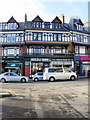
2
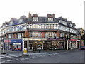
Western corner of Stanwell Road and Victoria Road, Penarth
A similar curve of shops is on the opposite corner. http://www.geograph.org.uk/photo/1972630
Image: © Jaggery
Taken: 5 Feb 2010
0.02 miles
3
Station Approach shops, Penarth
Shops and businesses on the south side of Station Approach include Guili Guili children's clothing and Paramount Restaurant.
Image: © Jaggery
Taken: 5 Feb 2010
0.02 miles
4
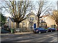
Stanwell Road Baptist Church, Penarth
Located near the eastern end of Stanwell Road.
Image: © Jaggery
Taken: 5 Feb 2010
0.02 miles
5
Stanwell Road Baptist Church hall, Penarth
The church hall is on the north side of Victoria Road ; the church http://www.geograph.org.uk/photo/1972732 is on the south side of Stanwell Road ; the backs of the two buildings are only a few metres apart.
Image: © Jaggery
Taken: 5 Feb 2010
0.02 miles
6
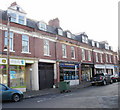
Royal Buildings shops, Penarth
Shops on the section of Royal Buildings directly opposite Station Approach include
Foxy's cafe and delicatessen, and Charles Sadler Ltd, fish, game & poultry dealer.
Between these premises is Boy's To Men Gentlemens Hair Dressers. (note to Penarth signwriters - next time you're working on Royal Buildings, move the apostrophe from Boy's to Gentlemen's).
Image: © Jaggery
Taken: 5 Feb 2010
0.02 miles
7
Penarth Conservative Club
The club, viewed from Victoria Road, is set back several metres from the north side of Stanwell Road.
Image: © Jaggery
Taken: 5 Feb 2010
0.02 miles
8
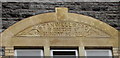
1887 inscription on Stanwell Road Baptist Church hall, Penarth
Located over the entrance here, http://www.geograph.org.uk/photo/5052924 the inscription records that the hall was built as a Sunday School in 1887.
Image: © Jaggery
Taken: 28 Jul 2016
0.02 miles
9
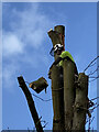
Tree surgeon
Tree surgeon at work on a tree next to the Paget Rooms, Penarth.
Image: © Alan Hughes
Taken: 25 Feb 2021
0.02 miles
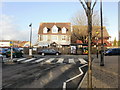
10

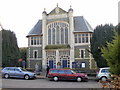
Paget Rooms, Penarth
Viewed across Victoria Road. Originally a cinema, built in 1906 on land donated by Earl of Plymouth. Now managed by Penarth Town Council, this is the town's public hall, which is used for a variety of local and touring events throughout the year. The building was Grade II listed in 1993.
Image: © Jaggery
Taken: 28 Jul 2016
0.03 miles