IMAGES TAKEN NEAR TO
Sully Road, PENARTH, CF64 2XP
Introduction
This page details the photographs taken nearby to Sully Road, CF64 2XP by members of the Geograph project.
The Geograph project started in 2005 with the aim of publishing, organising and preserving representative images for every square kilometre of Great Britain, Ireland and the Isle of Man.

There are currently over 7.5m images from over14,400 individuals and you can help contribute to the project by visiting https://www.geograph.org.uk
Image Map
Images are licensed for reuse under creativecommons.org/licenses/by-sa/2.0
Notes
- Clicking on the map will re-center to the selected point.
- The higher the marker number, the further away the image location is from the centre of the postcode.
Image Listing (6 Images Found)
Images are licensed for reuse under creativecommons.org/licenses/by-sa/2.0
Image
Details
Distance
1
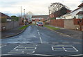
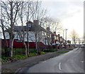
Redlands Avenue, Penarth
Viewed from Redlands Road.
Image: © Jaggery
Taken: 9 Dec 2012
0.12 miles
3
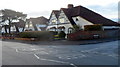
Corner of Redlands Road and Redlands Avenue, Penarth
Distinctively-roofed houses viewed across Redlands Road.
Image: © Jaggery
Taken: 9 Dec 2012
0.17 miles
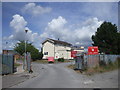
4
Footpath beside Ysgol Erw'r Delyn, Penarth
For those who don't know Welsh, Ysgol Erw'r Delyn is a Welsh-medium school.
Image: © John Lord
Taken: 6 Jul 2010
0.18 miles
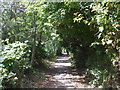
5
NW end of Wordsworth Avenue, Penarth
Viewed from the corner of Redlands Road.
Image: © Jaggery
Taken: 9 Dec 2012
0.22 miles
6
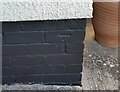
Ordnance Survey Cut Mark
This OS cut mark can be found on No57 Mountjoy Avenue. It marks a point 37.763m above mean sea level.
Image: © Adrian Dust
Taken: 17 Sep 2021
0.24 miles