IMAGES TAKEN NEAR TO
Rhodfa'r Morwydd, PENARTH, CF64 2UD
Introduction
This page details the photographs taken nearby to Rhodfa'r Morwydd, CF64 2UD by members of the Geograph project.
The Geograph project started in 2005 with the aim of publishing, organising and preserving representative images for every square kilometre of Great Britain, Ireland and the Isle of Man.

There are currently over 7.5m images from over14,400 individuals and you can help contribute to the project by visiting https://www.geograph.org.uk
Image Map
Images are licensed for reuse under creativecommons.org/licenses/by-sa/2.0
Notes
- Clicking on the map will re-center to the selected point.
- The higher the marker number, the further away the image location is from the centre of the postcode.
Image Listing (8 Images Found)
Images are licensed for reuse under creativecommons.org/licenses/by-sa/2.0
Image
Details
Distance
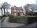
1
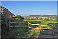
Dinas Powys from Sully Road - Morristown. Penarth
Image: © Mick Lobb
Taken: 13 Sep 2009
0.06 miles
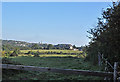
5
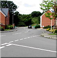
Northern end of Rhos Ddu, Lower Penarth
From the corner of Heol y Brenin.
Image: © Jaggery
Taken: 5 Aug 2016
0.22 miles
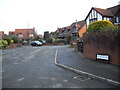
7
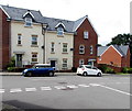
Cars and houses, Rhos Ddu, Lower Penarth
Viewed from the corner of Heol y Brenin.
Image: © Jaggery
Taken: 5 Aug 2016
0.24 miles
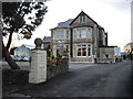
8
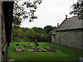
St. Peter's at Old Cogan, Vale of Glamorgan
Image: © Gareth James
Taken: 27 Aug 2010
0.25 miles