IMAGES TAKEN NEAR TO
West Court, Grove Terrace, PENARTH, CF64 2TN
Introduction
This page details the photographs taken nearby to West Court, Grove Terrace, CF64 2TN by members of the Geograph project.
The Geograph project started in 2005 with the aim of publishing, organising and preserving representative images for every square kilometre of Great Britain, Ireland and the Isle of Man.

There are currently over 7.5m images from over14,400 individuals and you can help contribute to the project by visiting https://www.geograph.org.uk
Image Map
Images are licensed for reuse under creativecommons.org/licenses/by-sa/2.0
Notes
- Clicking on the map will re-center to the selected point.
- The higher the marker number, the further away the image location is from the centre of the postcode.
Image Listing (127 Images Found)
Images are licensed for reuse under creativecommons.org/licenses/by-sa/2.0
Image
Details
Distance
1
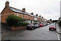
West along West Terrace, Penarth
From the corner of Dingle Road.
Image: © Jaggery
Taken: 28 Jul 2016
0.01 miles
2
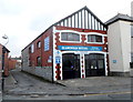
Glamorgan Motors Llandough Service Station, Penarth
Located on the corner of Grove Terrace and Bute Terrace (ahead). Despite the name of the service station, this location is in Penarth, about a mile from the Llandough boundary. http://www.geograph.org.uk/photo/3325493
Image: © Jaggery
Taken: 9 Dec 2012
0.01 miles
3
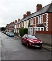
Houses on the north side of West Terrace, Penarth
Looking west from Dingle Road.
Image: © Jaggery
Taken: 28 Jul 2016
0.02 miles
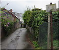
4
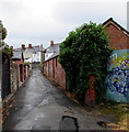
Lane towards Fairfield Road, Penarth
From Dingle Road near Dingle Road railway station.
Image: © Jaggery
Taken: 28 Jul 2016
0.02 miles
5
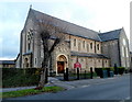
St. Joseph's RC church, Penarth
The Roman Catholic church is aligned exactly W-E along the north side of Wordsworth Avenue.
It was built in 1914-1915 to replace the original mid-Victorian RC church elsewhere in Penarth.
http://www.geograph.org.uk/photo/3345872 to another view
Image: © Jaggery
Taken: 9 Dec 2012
0.03 miles
6
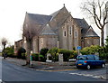
SE corner of St. Joseph's RC church, Penarth
This is the Wordsworth Avenue / Fairfield Road corner of the Roman Catholic church built in 1914-1915 to replace the original mid-Victorian RC church elsewhere in Penarth. http://www.geograph.org.uk/photo/3345867 to another view.
Image: © Jaggery
Taken: 9 Dec 2012
0.04 miles
7
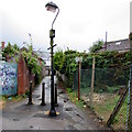
Metal posts across a Penarth path
A lamppost and three metal posts prevent vehicular misuse of the footpath from Dingle Road to Fairfield Road.
Image: © Jaggery
Taken: 28 Jul 2016
0.04 miles
8
Cycling Strictly Prohibited sign, Penarth
Alongside a lane from Dingle Road to Fairfield Road.
Strictly Prohibited is officialese. It means the same as Prohibited.
Image: © Jaggery
Taken: 28 Jul 2016
0.05 miles
9
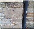
Ordnance Survey Cut Mark
This OS cut mark can be found on the SW angle of St Joseph's RC Church. It marks a point 38.146m above mean sea level.
Image: © Adrian Dust
Taken: 17 Sep 2021
0.06 miles
10
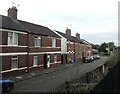
Dingle Road houses, Penarth
Viewed from Dingle Road railway station.
Image: © Jaggery
Taken: 19 Jun 2021
0.06 miles