IMAGES TAKEN NEAR TO
Cowper Close, PENARTH, CF64 2SU
Introduction
This page details the photographs taken nearby to Cowper Close, CF64 2SU by members of the Geograph project.
The Geograph project started in 2005 with the aim of publishing, organising and preserving representative images for every square kilometre of Great Britain, Ireland and the Isle of Man.

There are currently over 7.5m images from over14,400 individuals and you can help contribute to the project by visiting https://www.geograph.org.uk
Image Map
Images are licensed for reuse under creativecommons.org/licenses/by-sa/2.0
Notes
- Clicking on the map will re-center to the selected point.
- The higher the marker number, the further away the image location is from the centre of the postcode.
Image Listing (65 Images Found)
Images are licensed for reuse under creativecommons.org/licenses/by-sa/2.0
Image
Details
Distance
1
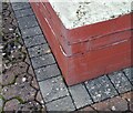
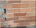
Ordnance Survey Cut Mark
This OS cut mark can be found on No18 Milton Road. It marks a point 37.091m above mean sea level.
Image: © Adrian Dust
Taken: 17 Sep 2021
0.08 miles
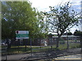
2
Wordsworth Avenue viewed from the corner of Shelley Crescent, Penarth
Looking west.
Image: © Jaggery
Taken: 9 Dec 2012
0.09 miles
4
Ordnance Survey Cut Mark
This OS cut mark can be found on No55 Cornerswell Road. It marks a point 36.149m above mean sea level.
Image: © Adrian Dust
Taken: 17 Sep 2021
0.11 miles
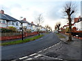
5
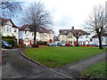
Wordsworth Avenue houses around a semicircle, Penarth
The grass semicircle on the north side of Wordsworth Avenue has a diameter of about 30 metres.
Image: © Jaggery
Taken: 9 Dec 2012
0.11 miles
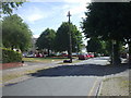
6
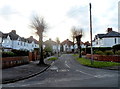
NE end of Coleridge Avenue, Penarth
Viewed across Wordsworth Avenue from the edge of St Joseph's RC church. http://www.geograph.org.uk/photo/3345867
Image: © Jaggery
Taken: 9 Dec 2012
0.12 miles
7
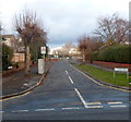
Southern end of Dryden Road, Penarth
Looking north towards Fairfield Primary School http://www.geograph.org.uk/photo/3345776 from Wordsworth Avenue.
Image: © Jaggery
Taken: 9 Dec 2012
0.12 miles
8
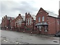
Victoria School
Victoria Primary School, Penarth.
Image: © Alan Hughes
Taken: 13 Jan 2016
0.13 miles
9
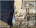
Ordnance Survey Cut Mark
This eroded badly OS cut mark can be found on No12 Machen Street. It marks a point 44.504m above mean sea level.
Image: © Adrian Dust
Taken: 17 Sep 2021
0.13 miles